The vocabulary, in plain language
Colorado River coverage runs on jargon, and most of it hides a simple idea. Everything this article uses, defined once:
| Term |
What it actually means |
| Acre-foot (af) |
One acre of land covered one foot deep — 1,233 m³, or 325,851 US gallons. Roughly half an Olympic swimming pool. |
| maf / kaf |
Million acre-feet (1 maf = 1.23 km³) and thousand acre-feet. The Colorado is always measured in these; Mead currently holds 7.06 maf, or 8.7 km³. |
| Upper Basin / Lower Basin |
The 1922 Compact split the river at Lee Ferry, Arizona. Above it: Colorado, New Mexico, Utah, Wyoming. Below it: Arizona, California, Nevada — plus Mexico further downstream. |
| Apportionment |
The volume each basin and state is legally entitled to draw, set by the 1922 Compact and the treaties and rulings layered on it. Entitlements were written for a bigger river than the one that exists. |
| Fill % |
Water currently stored ÷ the reservoir's capacity. Simple — except that "capacity" has more than one accepted definition, which is why the same lake gets two different percentages (see below). |
| Dead pool |
The elevation below which water can no longer flow out through the dam by gravity. Not "empty" — unusable. Mead's is around 895 feet; it currently sits near 1,041. |
| Minimum power pool |
The higher elevation below which the dam's turbines stop generating electricity. Hydropower fails well before water supply does. |
| Run-of-river reservoir |
A pool kept near full on purpose, to pass water downstream on schedule rather than to bank it. Mohave and Havasu are these; their healthy percentages say nothing about the river's health. |
| Shortage tier |
The step system that converts a Lake Mead elevation into a specific delivery cut for each Lower Basin state. Lower lake, deeper tier, bigger cut. |
| 24-Month Study |
Reclamation's rolling projection of where Mead and Powell will be over the next two years. The August edition is the one that has historically triggered the following year's tier. |
| Final EIS |
Final Environmental Impact Statement — the federal environmental-review document that legally underpins a decision of this size. A Record of Decision formally adopting it follows. |
| Sideboards |
Reclamation's own word for the outer limits in this plan: the widest and narrowest the taps can be set, with the exact annual numbers filled in later. |
| Snowpack |
Winter snow held in the Rocky Mountains, which melts in spring and is where essentially all of the Colorado's water comes from. Summer rain does not refill these reservoirs. |
What the plan actually does
The document is a Final Environmental Impact Statement for post-2026 Colorado River operations, published by Reclamation on 31 July 2026 and announced by the Department of the Interior. It replaces the interim guidelines that expire at the end of 2026, and its preferred alternative is described as an adaptive decision framework rather than a fixed schedule of cuts: Reclamation sets outer limits now and writes detailed operating guidelines at roughly two-year intervals, unless the basin states reach a longer-term consensus deal of their own.
Those outer limits — Reclamation calls them sideboards — are the substance of the plan:
| Sideboard |
Limit |
| Annual releases from Lake Powell |
5.0 – 12.0 maf |
| Maximum Lower Basin shortage |
3.0 maf/year (~40% of the Lower Basin apportionment) |
| Conserved water storable in Lake Powell |
up to 8.0 maf |
| Conserved water storable in Lake Mead |
up to 3.0 maf |
| Upper Basin conservation |
voluntary, up to 200 kaf (200,000 acre-feet), subject to hydrology |
| Framework duration |
through 2036 |
The near-term consequence reported alongside the release is the ~20% reduction for Arizona, California and Nevada over the next two years, with the 3.0 maf ceiling held in reserve for worse hydrology. Interior Secretary Doug Burgum framed it as preserving room for the states to negotiate: "This framework provides the flexibility to respond to changing hydrologic conditions while preserving the opportunity for Basin States to continue working toward durable, consensus-based solutions." The process began in June 2023; a draft came out in January 2026 and drew more than 18,000 comments, 785 of them unique.
The hydrological premise is not in dispute. The 1922 Colorado River Compact divided a river assumed to carry about 18 maf a year. Reclamation's own accounting puts average inflows for 2000–2024 at roughly 12.9 maf — and the Lower Basin alone used about 6.5 maf annually from 2020 to 2024, against the Upper Basin's 3.8 maf, out of some 13.1 maf of total use.
The scale test: 3.04 maf lost in twelve months
Policy volumes are hard to feel. Reservoir volumes are not. So here is the plan's headline number set against the actual water, using readings from Reclamation's own gauges as of 28 July 2026:
|
Lake Powell |
Lake Mead |
Combined |
| Storage now |
5.42 maf |
7.06 maf |
12.47 maf |
| Fill |
21.6% |
25.0% |
23.4% |
| One year ago (28 Jul 2025) |
7.51 maf (29.8%) |
8.00 maf (28.3%) |
15.51 maf |
| Change over 12 months |
−2.09 maf |
−0.95 maf |
−3.04 maf |
| Change over 24 months |
−4.29 maf |
−1.49 maf |
−5.78 maf |
In metric: the two reservoirs hold 15.4 km³ between them, down from 19.1 km³ a year ago — a loss of 3.75 km³ in twelve months. The plan's 3.0 maf ceiling is 3.70 km³.
Three readings fall out of that table.
First, the maximum cut is a one-year holding action. The 3.0 maf ceiling — the deepest shortage the framework allows in any single year — is within 1.5% of what the two reservoirs actually lost between July 2025 and July 2026. Imposed in full, in a repeat of this past year, it would roughly hold the line. It would not refill anything.
Second, the first phase is well short of that. Twenty percent of 6.5 maf is about 1.3 maf a year: roughly 43% of the last twelve months' decline, and about a tenth of the water currently banked in both reservoirs. That is a real reduction — it is not a recovery plan.
Third, the losses are lopsided. Powell accounts for 2.09 of the 3.04 maf lost. Mead's decline is a slow summer drawdown; Powell's is a failure to refill. July is normally Powell's seasonal peak, filled by Rocky Mountain snowmelt. This July it barely moved off its winter floor — the same thin-snowpack signature visible across the Colorado headwaters.
Line up the last six years at the start of August and the direction is unambiguous:
|
Aug 2021 |
Aug 2022 |
Aug 2023 |
Aug 2024 |
Aug 2025 |
Jul 2026 |
| Lake Powell |
31.4% |
24.8% |
37.2% |
38.6% |
29.8% |
21.6% |
| Lake Mead |
32.0% |
24.9% |
30.1% |
30.2% |
28.2% |
25.0% |
The wet winters of 2023 and 2024 lifted Powell into the high 30s and made recovery look plausible. Two lean years have handed all of it back and more: Powell is now below its 2022 crisis reading, and Mead is below the low it set that same summer.
Where the shortage is, and where the cuts land
The plan's asymmetry is its most contested feature: mandatory reductions for the three Lower Basin states, voluntary conservation for the four Upper Basin ones. The reservoir data does not settle that argument, but it does complicate the intuition behind it.
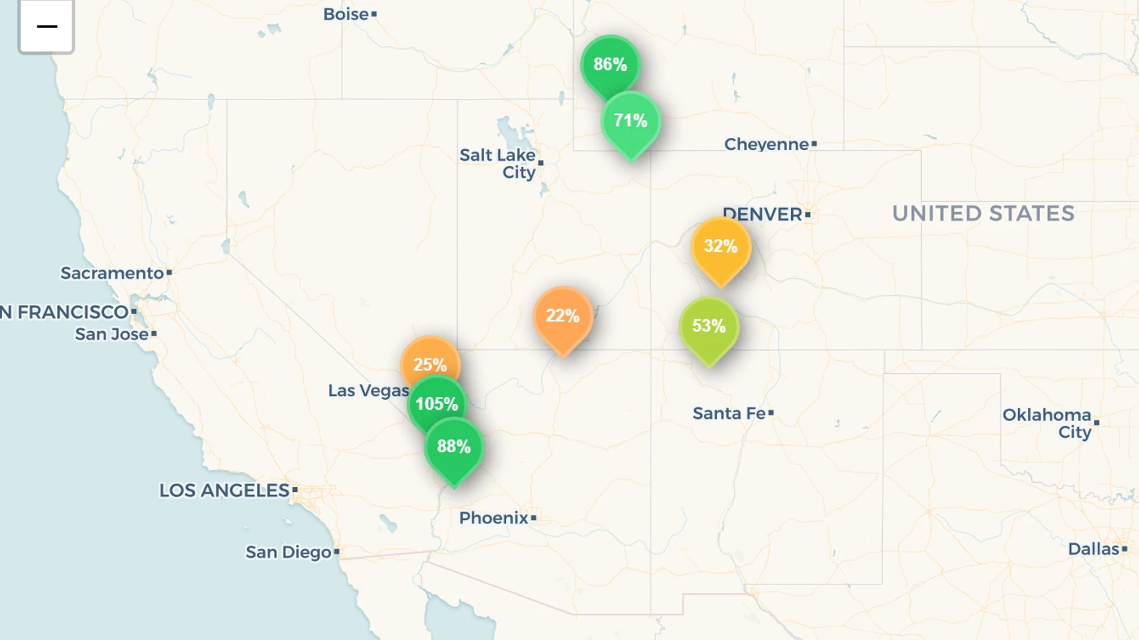
Here is every Colorado River system reservoir we track, on 28 July 2026, each set against its own July norm — the average fill it has held in July across our multi-year record, which is a fairer test than a raw percentage because every reservoir has a different natural operating range. (The map above shows the eight main ones; Morrow Point and Crystal are small pools immediately below Blue Mesa that smooth out its releases, and are held near constant by design.)
| Reservoir |
Basin |
State |
Fill |
July norm |
vs norm |
Capacity |
| Blue Mesa |
Upper |
CO |
32.1% |
~69.5% |
−37.4 pts |
0.75 maf |
| Navajo |
Upper |
NM |
52.6% |
~62.9% |
−10.3 pts |
1.71 maf |
| Flaming Gorge |
Upper |
UT |
70.6% |
~80.4% |
−9.8 pts |
3.79 maf |
| Lake Powell |
Upper |
UT |
21.6% |
~31.2% |
−9.6 pts |
25.03 maf |
| Lake Havasu |
Lower |
AZ |
87.5% |
~95.4% |
−7.9 pts |
0.61 maf |
| Lake Mead |
Lower |
NV |
25.0% |
~27.8% |
−2.8 pts |
28.26 maf |
| Lake Mohave |
Lower |
AZ |
105% |
~107.7% |
−2.7 pts |
1.59 maf |
| Fontenelle |
Upper |
WY |
85.6% |
~88.0% |
−2.4 pts |
0.33 maf |
| Morrow Point |
Upper |
CO |
95.6% |
~95.6% |
0.0 pts |
0.12 maf |
| Crystal |
Upper |
CO |
66.9% |
~66.0% |
+0.9 pts |
0.03 maf |
Sorted by how far each sits below its own normal, the top four are all Upper Basin reservoirs — the states the plan exempts from mandatory cuts. Blue Mesa, at 32% against a ~70% July norm, is 37 points below normal, the deepest deficit in the basin, and it sits in Colorado. Navajo (New Mexico) and Flaming Gorge (Utah) are each about 10 points down.
That is not, on its own, an argument that the Upper Basin is getting away with something. The Upper Basin's case is structural: its users are shorted by hydrology directly — when the snow does not fall, the water simply is not there — while Lower Basin deliveries are made from stored water in Mead and continue on schedule regardless. Upper Basin reservoirs being drawn down is, in that reading, exactly the involuntary shortage the Lower Basin is only now being asked to formalise. What the table does show is that the plan's geography of obligation and the plan's geography of empty reservoirs are not the same map.
Add every one of those ten reservoirs together and the Colorado River system is 30.5% full — 19.0 of 62.2 maf. Strip out the three run-of-river regulating reservoirs that Reclamation deliberately keeps near the brim (Mohave, Havasu, Morrow Point) and the system's actual water bank — Powell, Mead, Flaming Gorge, Navajo, Blue Mesa, Fontenelle — is 27.7% full.
Why Arizona reads 84% full and still takes the deepest cuts
State-level reservoir percentages are the most misread numbers in Colorado River coverage, and this plan will generate a lot of them. On our data, as of the same reading:
Read literally, the plan cuts the two fullest states and spares the two emptiest. Read correctly, it does nothing of the kind — because a state's tracked fill is not its Colorado River position:
- Arizona's 83.9% is Mohave and Havasu, run-of-river pools held near capacity by design so water can be passed to California, Arizona and Mexico on schedule. They are full in wet years and dry years alike. Arizona's actual Colorado River supply is stored in Mead — filed here under Nevada, because Hoover Dam sits on the Nevada side of the line.
- California's 70.6% is overwhelmingly its own in-state system — Shasta, Oroville, the State Water Project — which has nothing to do with the Colorado. California's Colorado entitlement is also drawn from Mead.
- Nevada's 28.1% and Utah's 31.1% are, in effect, single-reservoir readings: Mead is about 94% of Nevada's tracked capacity, Powell about four-fifths of Utah's.
- New Mexico's 24.5% is mostly Rio Grande storage — Elephant Butte and its neighbours — a different river in a different crisis. Its Colorado River reservoir is Navajo, at 52.6%.
The single defensible summary: the water Arizona, California and Nevada are being told to give up is not in Arizona, California or Nevada. It is in Lake Mead, and there are 7.06 million acre-feet of it left.
Why our page says 25% and the federal number says 27%
Coverage of the plan puts Lake Mead at 27% of capacity and elevation 1,041 feet. Our page says 25.0%. Both are correct, and both describe the same 7.06 million acre-feet of water.
Elevation, here, is the height of the lake's surface above sea level — the number Reclamation's rules are written around, because it is what the dam's intakes and turbines actually respond to. Mead's full pool is about 1,229 feet, so the lake is sitting more than 180 feet below the top of its own bathtub ring.
The difference is the denominator. We divide by Mead's total capacity of 34.9 km³ (28.26 maf). The 27% figure implies a denominator near 26.1 maf — Reclamation's smaller live-capacity baseline, which reflects sediment resurveys and excludes storage that cannot be released. Same lake, same day, same water; two conventions, two points apart. Powell shows the same effect for the same reason.
We flag this rather than quietly reconcile it, because the fix for a reader is simple and the trap is not: compare percentages only within one source, and compare volumes across sources. 7.06 maf is 7.06 maf on anyone's dashboard. This is the sort of thing the Reservoir Transparency Index exists to score — the United States publishes its reservoir data well; it does not always publish it comparably.
What to watch next
- Reclamation's August 24-Month Study. Under the expiring guidelines, the projection it publishes each August for Mead's 1 January elevation is what sets the following year's shortage tier — the mechanism that converts a reservoir reading into an enforceable cut. The new framework will define its own triggers in the operating guidelines that follow, but the input stays the same: where Mead's surface sits going into January, and it is drifting down through this summer.
- Next spring's snowpack. Neither reservoir refills from summer rain. Powell's recovery in 2023 came from one strong Rocky Mountain winter, and two weak ones erased it. The number that decides 2027 fell — or did not fall — as snow.
- The two-year guideline cycle. The framework only sets sideboards. The volumes that actually bind arrive in the operating guidelines Reclamation writes at roughly two-year intervals, and those can move within a very wide band: Powell releases anywhere from 5.0 to 12.0 maf, Lower Basin shortages from zero to 3.0.
- Whether the states cut a deal. The plan explicitly leaves room for a consensus agreement among the seven states to supersede federal guidelines. Twenty years of negotiation have not produced one.
- Glen Canyon's power pool. Below a minimum elevation, Glen Canyon Dam cannot generate. Powell at 21.6% is nearer that edge than Mead is to its own.
The honest summary: the federal government has capped how much water the Lower Basin can be told to give up at roughly the volume its two great reservoirs lost in the past twelve months — and the first phase of cuts is a little under half of that. Whether the framework stabilises the Colorado depends less on the ceiling than on how quickly Reclamation is willing to approach it.
Figures on this page are 28 July 2026 readings from the U.S. Bureau of Reclamation, mirrored with multi-year history on reservoirs.earth; "July norm" is each reservoir's average July fill in our record. For the levels themselves see Lake Mead and Lake Powell, July 2026; for the wider drought picture see the US Drought Monitor, July 2026 and US reservoir levels and the driest states. State editions: Arizona, Nevada, Utah, Colorado, New Mexico. Where every figure comes from: the official reservoir-data sources.