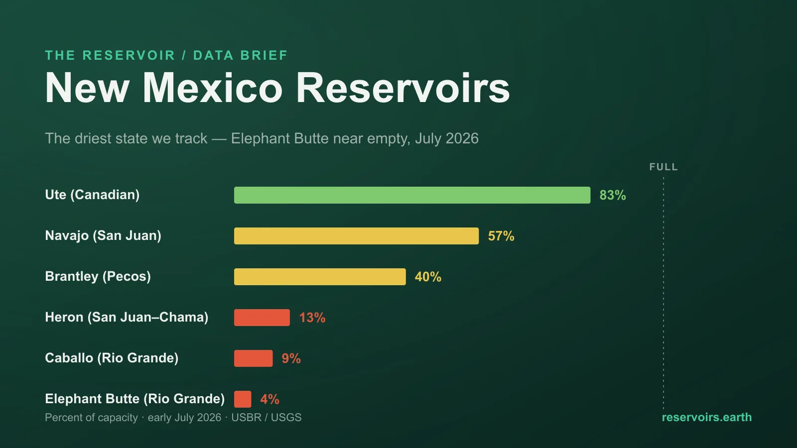
New Mexico is the driest reservoir state we track, at about 27% of capacity as summer sets in — and the number that defines it is Elephant Butte, the state's largest reservoir, sitting at roughly 3.6% full on the Rio Grande. Thirteen of the sixteen New Mexico reservoirs we track are below their normal level for early July. But the state is not uniformly empty; it is split by river. The Rio Grande system is in genuine crisis — Elephant Butte near empty, Caballo below it at ~9%, Heron at ~13% — while the San Juan in the northwest, part of the Colorado River basin, holds up far better: Navajo Reservoir is about 57%. In a state this dry, which river a reservoir sits on decides almost everything. Live figures are on the New Mexico page; the national picture is on the United States page.
Key takeaways
- New Mexico is the lowest-filled state in our US coverage, ~27% of capacity in early July 2026. Thirteen of the sixteen reservoirs we track are below their normal July level. Live figures are on the New Mexico page.
- Elephant Butte, the state's biggest reservoir, is near empty. At about 3.6%, it is at its lowest early-July level in at least five years, and it anchors the Rio Grande Project that irrigates southern New Mexico and West Texas.
- The Rio Grande system is the crisis. Below Elephant Butte, Caballo is ~9%; upstream, the San Juan–Chama import reservoir Heron is ~13%. The river's whole storage chain is running near the bottom.
- The San Juan basin is the exception. Navajo Reservoir in the northwest is about 57% — below its own normal, but in a different league from the Rio Grande reservoirs, because it draws on the Colorado River system.
- One low reservoir isn't drought at all. El Vado on the Rio Chama reads in the low teens because it is being held down for a multi-year dam-safety reconstruction, not because of the weather.
Where the data comes from
New Mexico's reservoirs come to us from federal gauges, with two agencies doing most of the work. The US Bureau of Reclamation runs the Rio Grande Project and San Juan–Chama reservoirs — Elephant Butte, Caballo, Heron, El Vado and Navajo — while the US Geological Survey (USGS) gauges others such as Ute, Eagle Nest and the small Santa Fe supply reservoirs. reservoirs.earth mirrors those gauges, adds multi-year history, and rolls them up by state. Every figure below is dated, because levels change daily; the live numbers and each reservoir's chart are on the New Mexico page and each reservoir's own page.
Two rivers, two outcomes
The single most useful thing to know about New Mexico's water is that its two big river systems are having opposite years.
The Rio Grande runs down the spine of the state, from the Colorado border through Albuquerque to the Texas line, and its storage is concentrated in a chain of Reclamation reservoirs that are almost all near their lows. Elephant Butte, the anchor, is at ~3.6%. Caballo, just downstream, is at ~9%. Even the imported water that props the system up — Colorado River water piped under the continental divide into the Rio Chama through the San Juan–Chama Project and stored in Heron — is down to ~13%. A dry winter over the southern Rockies and one of the earliest snowmelts on record left the whole Rio Grande chain short.
The San Juan, in New Mexico's northwest corner, is a tributary of the Colorado — and here the story inverts the one you might expect. Navajo Reservoir, the state's second-largest, holds about 57%. That is below its own July norm of ~65%, but it is a working reservoir with more than half its water, not a near-empty one. It is a useful reminder that "the Colorado River basin is in trouble" and "this particular Colorado-basin reservoir is fine" can both be true: Navajo is an upstream storage reservoir that has been managed with water in the bank, unlike the vast, over-drawn mainstem reservoirs far downstream.
The current picture (as of early July 2026)
The Rio Grande system — the state's water spine, and its crisis:
| Reservoir |
River / role |
Fill |
Normal (early Jul) |
| Elephant Butte |
Rio Grande — main storage |
3.6% |
~11% |
| Caballo |
Rio Grande — re-regulation |
9% |
~13% |
| Heron |
San Juan–Chama import |
13% |
~26% |
| El Vado |
Rio Chama — under repair |
12% |
(see note) |
The rest of the state — healthier in the northwest and northeast, low in the Pecos:
| Reservoir |
River / area |
Fill |
Normal (early Jul) |
| Ute |
Canadian (NE) |
83% |
~79% |
| Navajo |
San Juan (NW) |
57% |
~65% |
| Brantley |
Pecos (SE) |
40% |
~63% |
| Eagle Nest |
Cimarron (N) |
31% |
~45% |
| Lake Sumner |
Pecos (E) |
14% |
~19% |
Ute Reservoir on the Canadian River is the state's one clearly above-normal reservoir, at ~83%. Everywhere else the reading is below the July norm, and the Pecos reservoirs (Brantley, Sumner) are well short — a third river system, a third version of the same dry year.
Elephant Butte's five-year July slide
The best way to see the Rio Grande drought is not one snapshot but the trend. Here is early-July fill over five straight years for the river's main reservoirs, with Navajo alongside to show the San Juan running a different race:
| Reservoir |
Jul 2022 |
Jul 2023 |
Jul 2024 |
Jul 2025 |
Jul 2026 |
| Elephant Butte |
7% |
28% |
16% |
6% |
4% |
| Caballo |
10% |
21% |
17% |
10% |
9% |
| Heron |
19% |
41% |
35% |
19% |
13% |
| Navajo |
55% |
76% |
71% |
62% |
57% |
Elephant Butte briefly recovered to 28% in the wetter summer of 2023, then gave it all back and more: 2026's ~4% is its lowest early-July reading in the five-year record. The Rio Grande reservoirs move together — up in 2023, down hard since — because they share one water source and one bad run of winters. Navajo, on the San Juan, drifts in a narrower, higher band. Same state, two rivers, two outcomes.
The reservoir that's low on purpose
Not every low number here is drought. El Vado Lake on the Rio Chama reads in the low teens, but that is by design: its dam has been undergoing a multi-year Reclamation safety reconstruction, and the reservoir has been kept drawn down through the work rather than filled. Reading it as a drought casualty would be a mistake — it is a construction site with water held low on purpose, the New Mexico equivalent of Arizona's regulating reservoirs or Houston's dry flood-control basins: a reservoir whose level says more about what it is for right now than about the weather.
What reservoir levels do — and don't — tell you here
- The river is the unit, not the state. New Mexico's ~27% average blends a near-empty Rio Grande, a half-full San Juan, a low Pecos and an above-normal Canadian. No one lives on the average; they live on their own basin, which is why the reservoir-by-reservoir view matters more here than almost anywhere.
- Imported water is still water that has to exist somewhere. Part of the Rio Grande's supply is Colorado River water moved through the San Juan–Chama Project and stored in Heron. When that reservoir is at 13%, the usual backstop for a dry Rio Grande is thin too.
- Storage is the lagging half of the story. These levels record the winter that just ended and the irrigation season now under way. Whether the Rio Grande reservoirs get any relief depends on the summer monsoon over the southern Rockies — which storage cannot forecast.
What it means for the summer
The practical read for 2026: southern New Mexico and the Rio Grande Project it shares with West Texas are entering summer with almost no reservoir cushion. When Elephant Butte is near empty, the irrigation season it supplies is short and tightly rationed, and the river through Albuquerque and below runs on whatever the mountains and the monsoon send, not on stored water. The northwest, on the San Juan, and the northeast, on the Canadian, are in far better shape — Navajo more than half full, Ute above normal — but they serve different communities and cannot backfill the Rio Grande. There is no plumbing that moves the northwest's water to the southern valleys.
The honest summary: the driest state we track, defined by a near-empty Elephant Butte and a Rio Grande chain running on its lowest storage in years — with a healthier San Juan corner that belongs to a different river and can't come to the rescue.
FAQ
What are New Mexico's reservoir levels right now?
About 27% of capacity statewide as of early July 2026 — the lowest of any state we track — with 13 of 16 reservoirs below their normal July level. The state's largest reservoir, Elephant Butte, is at about 3.6%. Live figures are on the New Mexico page.
How full is Elephant Butte in July 2026?
About 3.6% of capacity — its lowest early-July reading in at least five years. It is the anchor of the Rio Grande Project, which supplies irrigation in southern New Mexico and the El Paso area of West Texas, so its level has direct consequences for that season's water deliveries.
Is New Mexico in a drought in 2026?
Yes, especially in the Rio Grande and Pecos basins. A dry winter and an early snowmelt over the southern Rockies left the Rio Grande reservoirs near empty. The San Juan (northwest) and Canadian (northeast) basins are in better shape, so it is worst along the state's central and eastern rivers.
Why is Navajo Reservoir so much fuller than Elephant Butte?
They sit on different rivers. Navajo is on the San Juan, part of the Colorado River system, and is managed as an upstream storage reservoir that has kept water in reserve; Elephant Butte is on the Rio Grande, which has had a run of dry winters and heavy irrigation demand.
Where does the data come from?
The US Bureau of Reclamation for the Rio Grande Project and San Juan–Chama reservoirs, and the US Geological Survey for others, mirrored with multi-year history on reservoirs.earth.
This is a July 2026 snapshot of New Mexico; for the national picture and where drought risk actually sits across the US, see the US reservoir levels edition and the neighbouring Texas and Arizona editions. How US water-data openness ranks is on the Reservoir Transparency Index.