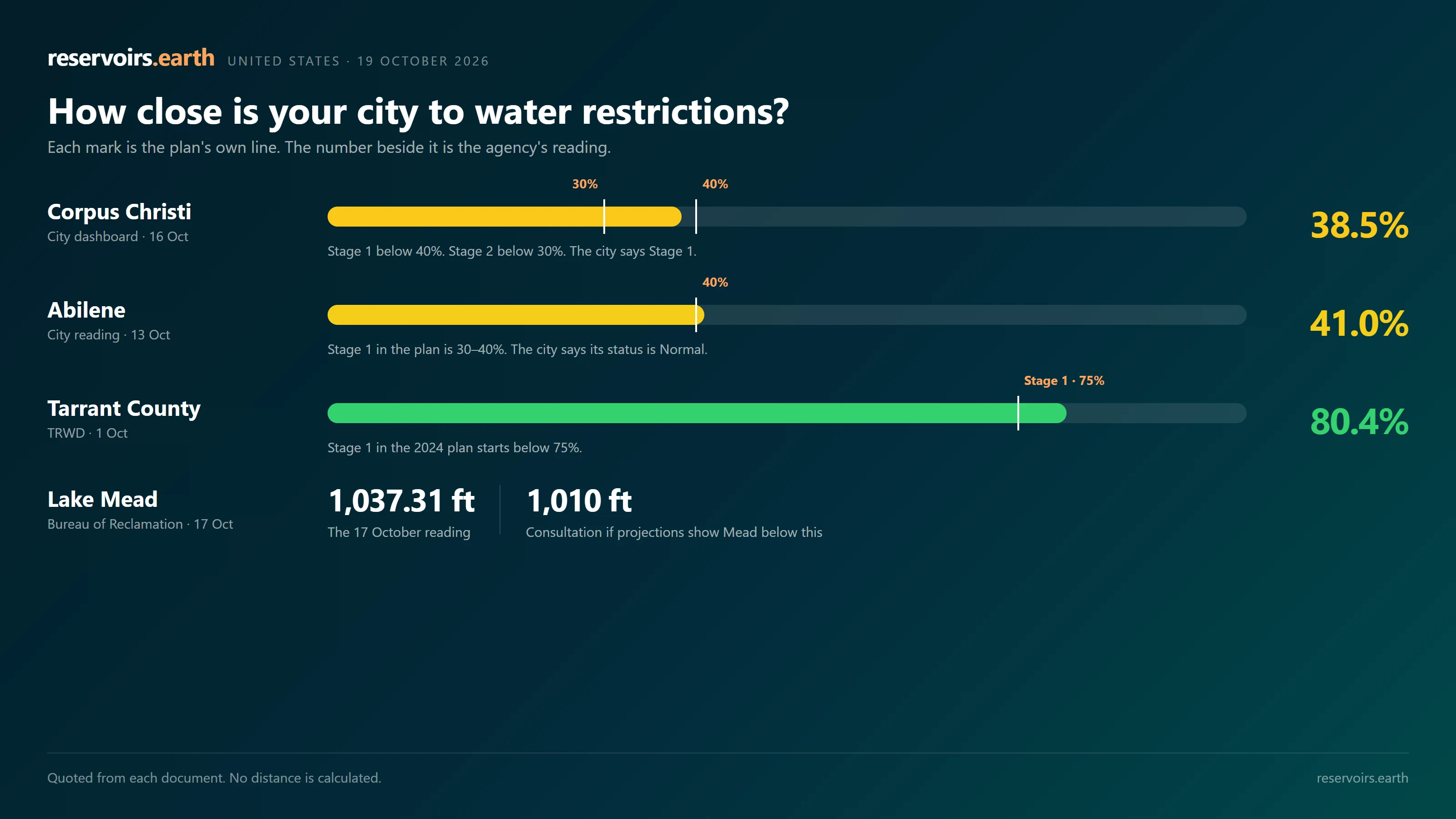
This page does not decide whether a restriction applies, and it does not estimate when one will start. It quotes two things, separately: the next line written in the drought plan or the state or federal rule, and the latest figure published by the agency that owns that figure. The utility's own order is the rule that binds a customer.
The page covers 44 water systems in 22 states and the District of Columbia. A stage is named only when that utility or agency has stated it. A news report is not used. An undated figure is not used. A reservoir total that is not the denominator in the plan is not placed next to the plan's line.
A stage is the name in that plan. It is not a national scale. Where the plan states what the stage requires of a customer, that rule is quoted in one sentence below. Where it does not, the page says so. Quoting the rule is not a finding that it applies to a particular address today.
Key takeaways
- Corpus Christi's plan sets Stage 2 below 30% of combined storage in Choke Canyon and Lake Corpus Christi. The city dashboard read 38.5% on 16 October 2026, and the city says it is in Stage 1. A sum of Texas Water Development Board volumes on 19 October is 37.98%. That sum is not the city's legal figure, and the two are not subtracted here.
- Abilene's plan puts Stage 1 at 30–40%. The city reported 41.0% on 13 October and says its status is Normal. TWDB's reading for the same two lakes was 41.76% on 18 October.
- The Bureau of Reclamation read Lake Mead at 1,037.31 feet on 17 October. The 2027–28 guidelines cut the Lower Basin by 1.25 million acre-feet a year, and they call for consultation if projections show Mead below 1,010 feet. Reclamation's own daily projection for 30 November is about 1,035.64 feet.
- The National Weather Service's Tampa Bay statement of 16 October gives reservoir storage of 11.82 billion gallons on 15 October, about 76% of a 15.5 billion gallon capacity, and reports that the Southwest Florida Water Management District's Modified Phase III order runs to 31 March 2027.
National summary table
| System / city | State | What is measured | Plan's next line | Latest quoted figure | Source |
|---|---|---|---|---|---|
| Corpus Christi | TX | Choke Canyon + Lake Corpus Christi | Stage 2 below 30% | 38.5% (16 Oct, city); city says Stage 1 | City DCP |
| Abilene | TX | Fort Phantom Hill + Hubbard Creek | Stage 1 at 30–40% | 41.0% (13 Oct, city); city says Normal | City of Abilene |
| Fort Worth (TRWD) | TX | Bridgeport, Eagle Mountain, Richland-Chambers, Cedar Creek | Stage 1 below 75% | 80.4% (1 Oct, district) | TRWD |
| Wichita Falls | TX | Arrowhead + Kickapoo | Stage 1 below 65% | TWDB acre-feet on 18 Oct (see below) | City DCP |
| North Texas MWD | TX | Lavon + Bois d'Arc | Stage 1 below 60% from 1 Nov; below 70% until then | TWDB acre-feet on 18–19 Oct (see below) | NTMWD DCP |
| Dallas | TX | DWU's own share of seven lakes | Stage 1 below 65% of that share | Not published daily | Dallas Water Utilities |
| Austin | TX | Travis + Buchanan | Stage 1 below 1.4 million acre-feet | 1,865,056 acre-feet (19 Oct, TWDB sum of the two lakes) | Austin DCP |
| San Angelo | TX | Months of supply, all sources | Level 1 below 24 months | Not used (the city's months figure is undated) | City of San Angelo |
| Lower Colorado Basin | AZ/CA/NV | Lake Mead elevation | Consultation if projections show Mead below 1,010 ft | 1,037.31 ft (17 Oct, Reclamation) | Reclamation |
| Tucson | AZ | Lake Mead elevation | Tier 3 below 1,025 ft | 1,037.31 ft (17 Oct, Reclamation); city says Tier 2 | Tucson Water |
| Las Vegas (SNWA) | NV | Lake Mead, via the federal allocation | 2027–28 guidelines: Nevada reduction of 50,000 acre-feet a year | 1,037.31 ft (17 Oct, Reclamation) | Reclamation |
| Lake Powell | UT/AZ | Lake Powell elevation | 3,510 ft operating target | 3,520.31 ft (17 Oct) | USGS 09379900 |
| Marin County | CA | Seven reservoirs, tested around 1 April | Level 1 below 65,000 acre-feet on that test | 63,666 acre-feet (14 Oct, Marin Water) | Marin Water |
| East Bay MUD | CA | Projected total storage at the end of September | Stage 1 at 475–425 thousand acre-feet | 83% of capacity (17 Oct, district) | EBMUD |
| San Francisco (SFPUC) | CA | Regional system, acre-feet | 10% voluntary below 1.1 million acre-feet | 89% (1 Sep, utility report) | SFPUC |
| Wichita | KS | Cheney, 12-month average | Stage 2 at 50–69% | 98.8% average (October, city); city says Stage 1 | City of Wichita |
| Oklahoma City | OK | Combined accessible storage | Stage 2 at or below 50% | Combined percent not published | OKC Utilities |
| Raleigh | NC | Falls Lake supply pool, seasonal curve | End-of-September line: 45% | 71% (13 Oct, city). October line not confirmed | City of Raleigh |
| Greensboro | NC | Townsend, Higgins, Brandt | Not confirmed in the plan | Not stated | City of Greensboro |
| Durham | NC | Model, plus days of supply | Stage 3 on the city's model | 88 days of easily accessible supply (15 Oct, city); city says Stage 2 | City of Durham |
| Washington metro | DC/MD/VA | Jennings Randolph + Little Seneca | Warning at or below 60% for five days | 100% and 98% (6 Oct, ICPRB) | ICPRB |
| NYC / Delaware Basin | NY/NJ/PA/DE | Cannonsville, Pepacton, Neversink, vs a rule curve | Watch after five days below the curve | 82.7% system storage (16 Oct, DEP); curve value not confirmed | NYC DEP |
| Boston (MWRA) | MA | Quabbin, seasonal bands | October Warning band: 52.5–67.5% | 77.5% (1 Oct, MWRA) | MWRA |
| Tampa Bay | FL | Regional reservoir, as cited by NWS | Order already reported in effect | 11.82 billion gallons (15 Oct, NWS statement) | NWS Tampa Bay |
State-level summary
| State | What the state requires | Systems on this page |
|---|---|---|
| Texas | Each public water supplier files a drought contingency plan with numeric triggers (TCEQ). | 10 |
| California | Water Code §10632 requires a six-level Water Shortage Contingency Plan from each urban supplier. | 6 |
| Arizona | Colorado River shortage tiers are set by Reclamation. City plans add their own tiers. | 2, plus Lake Mead |
| Nevada | Colorado River shortage tiers, and SNWA's own rules. | 1 |
| Colorado | No statewide numeric trigger. Each utility has its own plan. | 3 |
| Utah | Utility and conservancy-district plans. | 3, plus Lake Powell |
| New Mexico | Utility plans. | 1 |
| Kansas | Utility plans. | 1 |
| Oklahoma | Utility plans. | 1 |
| Georgia | Statewide drought response levels, set by EPD. | 1 |
| North Carolina | Local water shortage response plans (15A NCAC 02E .0600). The Catawba uses a Low Inflow Protocol. | 5 |
| South Carolina | The Catawba-Wateree protocol is shared with North Carolina. | 1, shared |
| Virginia / Maryland / DC | A regional Potomac plan run by ICPRB and MWCOG. | 2 |
| Florida | Water-management-district restrictions. | 1 |
| New York / New Jersey / Pennsylvania / Delaware | DRBC rule curves on the three NYC Delaware reservoirs. New Jersey uses several indicators. | 2 |
| Massachusetts | MWRA bands for Quabbin, plus state drought declarations. | 1 |
| Oregon | Utility plans. | 1 |
| Washington | Utility plans. | 1 |
Shared systems are counted once. That is 44 systems across 22 states plus DC.
Texas
TCEQ requires each retail and wholesale supplier to adopt a drought contingency plan with specific triggers. The Texas Water Development Board publishes daily storage for major reservoirs. A percentage computed from those volumes is a sum of the board's conservation storage over conservation capacity. It is labeled as that sum. It is not treated as the city's legal reading.
Corpus Christi
The city's drought contingency plan uses combined storage in Choke Canyon Reservoir and Lake Corpus Christi. Lake Texana and the Mary Rhodes pipeline are outside that test. The plan's bands are below 50% (drought watch), below 40% (Stage 1), below 30% (Stage 2) and below 20% (Stage 3). A separate Level 1 water emergency applies at 180 days of supply.
The city dashboard reported 38.5% on 16 October. The city says it is in Stage 1. In the plan, Stage 1 limits hose-end sprinklers and automatic irrigation to once a week, on a day the city assigns, and allows a hand-held hose, a bucket of five gallons or less, or drip irrigation on any day. The plan's target for that stage is a 5% cut in daily demand. Stage 2 keeps those rules and moves sprinklers to once every other week, with a 10% target.
TWDB volumes on 19 October were 141,890 acre-feet in Choke Canyon and 207,082 in Lake Corpus Christi, which is 37.98% of 918,882 acre-feet of combined conservation capacity. The same sum was 38.55% on 12 October and 39.92% on 19 September. The city has reported the same lakes at 12.1% a year earlier. Lake pages: Choke Canyon, Lake Corpus Christi, Lake Texana.
Abilene
The plan uses combined storage in Fort Phantom Hill and Hubbard Creek. Stage 1 applies at 30–40%, Stage 2 at 20–30%, and Stage 3 below 20%. The city reported 41.0% on 13 October and says its status is Normal. That status, on the city's own page, is two watering days a week: odd addresses Thursday and Sunday, even addresses Tuesday and Saturday, from midnight to 10 a.m. and from 6 p.m. to midnight. Stage 1 in the city code is a different rule. It limits sprinklers to one day in seven, in the same hours. The city is not in that stage.
TWDB's volumes for the same two lakes give 41.76% on 18 October and 41.97% a month earlier.
Fort Worth and Tarrant County (TRWD)
The district supplies Fort Worth, Arlington, Mansfield and other cities. Its 2024 plan uses combined storage in Bridgeport, Eagle Mountain, Richland-Chambers and Cedar Creek. Stage 1 starts below 75%, Stage 2 below 60%, Stage 3 below 45%. Stage 1 in that plan is called Water Watch. The general manager may order the listed actions, and a mandatory customer measure requires notice to the state. The listed sprinkler rule is twice a week: non-residential sites Tuesday and Friday, even addresses Wednesday and Saturday, odd addresses Thursday and Sunday, with Monday off. No hose-end or automatic spray irrigation from 10 a.m. to 6 p.m. A handheld hose, soaker hose, or drip system may be used any day. The plan's goal for the stage is a 5% reduction.
TRWD reported 80.4% on 1 October and 83.7% on 1 September. TWDB volumes for the four lakes give 81.18% on 19 October and 81.64% on 19 September. The district and the board do not use the same capacity figures.
Wichita Falls
The plan uses combined storage in Lake Arrowhead and Lake Kickapoo. Stage 1 is below 65%, Stage 2 below 50%, Stage 3 below 40%, Stage 4 below 30%, Stage 5 below 25%. Stage 1 in the 2024 plan limits sprinklers to two days a week: even addresses Monday and Thursday, odd addresses Tuesday and Friday. Spray irrigation is not allowed from 10 a.m. to 7 p.m. A hand-held hose with a shutoff, a soaker hose, a bucket, a bubbler, or drip irrigation is allowed any day. The plan's goal for the stage is a 5% reduction.
TWDB recorded 162,376 acre-feet in Arrowhead and 69,569 in Kickapoo on 18 October. That is 73.24% of 316,704 acre-feet of combined conservation capacity, against 72.91% a month earlier. No dated city percentage is quoted. Lake pages: Lake Arrowhead, Lake Kickapoo.
North Texas Municipal Water District
NTMWD serves Plano, McKinney, Frisco, Garland, Richardson and more than 80 other communities. In the plan, Stage 1 is below 70% from April through October and below 60% from November through March. Stage 2 is below 55% and below 45% in those same seasons. Stage 3 is below 30% and below 20%. The district is a wholesaler. Stage 1 of its plan does not set one watering calendar. It requires member cities to start Stage 1 of their own plans. The district's goal for the stage is a 2% reduction in annual use. Stage 2's goal in the same plan is 5% a year, and the measures the district may then require include sprinklers once a week from April through October.
On 19 October, Lavon Lake held 326,368 acre-feet. On 18 October, Bois d'Arc Lake held 323,788 acre-feet. The TWDB sum of the two is 83.64% of combined conservation capacity, against 85.60% a month earlier. Lavon Lake.
Dallas
The 2024 plan sets Stage 1 below 65% of Dallas Water Utilities' own share of conservation storage, Stage 2 below 50% and Stage 3 below 35%. That share is not published daily. No current figure is given, because a regional total includes water the utility does not own. Stage 1 in the plan is a menu. The water director chooses the actions. The listed landscape rule is the city ordinance already in force all year: hose-end sprinklers and automatic systems no more than two days a week, Sunday and Thursday for even addresses, Saturday and Wednesday for odd addresses. The plan's target for the stage is a 5% cut in gallons per person per day. Stage 2 adds, if the director orders it, a maximum of one watering day a week, and its target is 15%. Lake pages: Ray Roberts, Lewisville, Grapevine, Ray Hubbard.
Austin (LCRA)
The plan uses combined storage in Lake Travis and Lake Buchanan. Stage 1 starts below 1.4 million acre-feet. Stage 2 starts below 900,000 acre-feet, or below 1.1 million acre-feet when inflows are below 25% of normal. In the adopted plan, Stage 1 limits automatic irrigation to once a week, from midnight to 8 a.m. or 7 p.m. to midnight, on an assigned weekday. Drip irrigation is twice a week in those hours. A hose-end sprinkler is twice a week, from midnight to 10 a.m. or 7 p.m. to midnight, on an assigned weekday and weekend day.
TWDB volumes on 19 October were 1,034,455 acre-feet in Travis and 830,601 in Buchanan, 1,865,056 combined. A month earlier the same sum was 1,836,684. Lake Travis, Lake Buchanan.
San Angelo
The plan uses months of supply from all sources. Level 1 is below 24 months, Level 2 below 18, Level 3 below 12. The city's months figure has no date on the page used here, so it is not quoted.
TWDB's area figure on 18 October was 29.8% of reservoir capacity, with Twin Buttes at 4.5% and O.C. Fisher at 10.5%. Those percentages are not the city's test. The plan counts groundwater and O.H. Ivie as well as the reservoirs.
San Antonio (SAWS) and Lubbock
San Antonio's stages follow the Edwards Aquifer. The J-17 index well read 640.6 feet on 17 October, and SAWS says it is in Stage 3. On the utility's Stage 3 page, an irrigation system, sprinkler, or soaker hose may run once a week, from 5 to 10 a.m. and from 9 p.m. to midnight, on the day set by the last digit of the address. A hand-held hose is allowed any day. The same page states a surcharge on single-family use above 20,000 gallons in a month. Lubbock's plan has no fixed storage percentage that could be verified, and the page used here does not state a household rule. Lake Alan Henry was at 73.6% on 18 October. That reading is storage, not a stage.
For the state map, see Texas reservoir levels and Texas reservoir levels, July 2026.
Colorado River: Arizona, Nevada, California and Utah
Lake Mead and the Lower Basin
Reclamation's reading for Lake Mead was 1,037.31 feet on 17 October. The 2027–28 guidelines put the Lower Basin in a shortage and cut 1.25 million acre-feet a year: Arizona 760,000, California 440,000, Nevada 50,000.
The same guidelines call for consultation if projections show Mead below 1,010 feet. Below 950 feet, Hoover Dam can no longer generate power. Reclamation's daily projection for 30 November is about 1,035.64 feet. Background: Lake Mead water level, Colorado River water cuts 2026, Lake Mead reservoir page.
Lake Powell
The 17 October reading was 3,520.31 feet. The operating target cited for Glen Canyon Dam's power pool is 3,510 feet. USGS daily values were 3,517.3 feet on 8 September and 3,518.8 feet on 13 October. Water-year 2027 releases are planned at 6 to 7 million acre-feet. See Lake Powell water level.
Tucson, Arizona
Tucson Water's plan ties its tiers to Lake Mead. Tier 0 is 1,090–1,075 feet, Tier 1 is below 1,075, Tier 2 is below 1,045, and Tier 3 is below 1,025 or when Central Arizona Project deliveries fall below potable demand. The city says it is in Tier 2. The elevation quoted above is Reclamation's 17 October reading. On the city's drought page, Tier 2 continues the earlier tiers and requires a water audit from a customer still above the use guidelines. The mayor and council may consider a drought surcharge. The page does not set a lawn-watering calendar for the tier.
Phoenix, Arizona
The city says it is in Stage 1. Its plan sets no elevation that forces the next stage. The city page used here does not state what Stage 1 requires of a customer. See Arizona reservoirs and Roosevelt Lake.
Las Vegas, Nevada (SNWA)
The guidelines reduce Nevada's Colorado River allocation by 25,000 acre-feet a year when Mead is at or below 1,050 feet. The 2027–28 guidelines set that reduction at 50,000 acre-feet a year. See Nevada reservoirs.
California
Water Code §10632 requires every urban supplier to keep a Water Shortage Contingency Plan with six shortage levels. Each utility chooses the test.
Marin County (Marin Water)
The plan tests total storage in seven reservoirs around 1 April. Level 1 is below 65,000 acre-feet, then 55,000, 45,000, 35,000 and 25,000. On 14 October, Marin Water reported 63,666 acre-feet, 80.22% of capacity and 121% of the average for the date. The 14 October reading is not the April test. Level 1 in the 2024 plan is a shortage of up to 10%, declared by the board. The plan's table applies the same baseline rules at every level, including a ban on landscape irrigation from 9 a.m. to 7 p.m. and a ban during and for 48 hours after measurable rain. A tighter day limit is listed as an example the district may impose. It is not stated here as a rule in force.
East Bay MUD
The plan uses projected total storage at the end of September. Stage 1 is 475 to 425 thousand acre-feet, Stage 2 is 425 to 390, Stage 3 is 390 to 325, and Stage 4 is below 325. On 17 October the district reported 83% of capacity and 115% of average. The report does not give acre-feet, and it does not state a household rule for those stages.
San Francisco (SFPUC)
The plan's regional-storage lines are 1,285,000 acre-feet or more (no cutback in the plan), below 1,100,000 (10% voluntary), below 900,000 (20% mandatory) and below 500,000 (25%). Regional capacity in the plan is 1,471,494 acre-feet. The utility's August hydrological report put the system at 89% on 1 September. That is the latest figure in that report.
San Luis Obispo, Santa Cruz and Santa Barbara
San Luis Obispo's plan runs from a Watch below 5 years of supply to Critical below 2.5 years. No dated years-of-supply figure was found. Santa Cruz's stages use a projected shortage, not a storage percentage. Loch Lomond was reported 98% full in late April, and nothing later was found. Santa Barbara's plan sets no fixed Lake Cachuma trigger. See California reservoirs.
Colorado
There is no statewide numeric trigger.
Denver (Denver Water)
Denver Water says it declared Stage 1 on 25 March. It reported system storage at 73% on 20 August, against a median of 94% for the date. The plan has no fixed percentage. The board decides the next stage. A board resolution effective 1 October 2026 prohibits watering grass, and prohibits all spray irrigation, until the board acts again. Trees, shrubs, and perennials may be watered any day with a hand-held hose that has a shutoff nozzle, or with low-volume irrigation that does not spray. The declaration runs through 30 April 2027, or until the board changes it.
Colorado Springs
The utility's rule imposes mandatory restrictions when supply is projected to fall below 1.5 years of demand by 1 April. In September it reported the system 61% full, equal to 2.4 years of demand, and described its status as Water Shortage Preparation. That notice does not state a household watering rule.
Aurora
The plan's bands are Stage 1 at 19–24 months of supply, Stage 2 at 10–18 months, and Stage 3 at 9 months or less. Aurora Water says it has been in Stage 1 since 7 April. No dated months-of-supply figure was found. The page used here does not state what Stage 1 requires of a customer. See Colorado reservoirs.
Utah
Weber Basin
The district serves Davis, Weber, Morgan and Summit counties. Its bands use projected 1 June storage, and the moderate band starts between 380,000 and 360,000 acre-feet. No dated district storage figure, and no district order, is quoted.
Salt Lake City and Washington County
Salt Lake City Public Utilities says it is in Stage 2 of a plan that compares supply with demand. The plan has no fixed storage percentage. The drought page used here does not state what Stage 2 requires of a customer. Washington County Water Conservancy District, which serves St. George, publishes no fixed reservoir trigger. See Utah reservoirs and Deer Creek Reservoir.
Kansas
Wichita
The city's stages use the 12-month average of Cheney Reservoir's conservation pool: Stage 1 at 70–89%, Stage 2 at 50–69%, Stage 3 at 35–50%, Stage 4 at 0–34%. The October drought update reports a 12-month average of 98.8% and Cheney at 92.5%. The city says Stage 1 remains in place. That update does not state what Stage 1 requires of a customer. See Kansas reservoirs.
Oklahoma
Oklahoma City
The plan's Stage 1 is a permanent odd/even watering rule. Stage 2 is at or below 50% of combined accessible storage, then 45%, 40% and 35%. No daily combined percentage was found. Canton Lake, one reservoir in that system and not the combined test, was at 69.6% on 16 October according to USACE. See Oklahoma reservoirs.
Georgia
Atlanta metro
The state Environmental Protection Division sets drought response levels from several indicators, Lake Lanier among them. The state level for metro Atlanta is Level 1. The division's notice of 27 April 2026 says that declaration requires a public information campaign, and that outdoor water use between 4 p.m. and 10 a.m. remains allowed. Lake Lanier was at 88.0% of capacity on 16 October (Lake Lanier). The plan does not publish a storage line for Level 2. See Georgia reservoirs.
North Carolina and South Carolina
North Carolina requires local water shortage response plans. The Catawba-Wateree basin, shared with South Carolina, uses a Low Inflow Protocol.
Durham
The city says it has been in Stage 2 since 15 June. Its plan moves a stage when the city's model shows at least a 20% chance that storage falls below 35% within 10 weeks. On the city's Stage 2 page, spray irrigation is prohibited, including a hose-end sprinkler. Hand watering, drip irrigation, and a tree or shrub watering bag are allowed. Restaurants serve drinking water only on request. On 15 October the city reported 88 days of easily accessible supply and 151 days of total supply. It reported Lake Michie at about 40% full when Stage 2 was declared.
Charlotte and the Catawba-Wateree basin
The Catawba-Wateree Drought Management Advisory Group says the basin is in Low Inflow Protocol Stage 2. The group said the stage was still in effect on 15–16 October. Percentage bands for the protocol were not verified, and none are quoted. The documents used here do not state a household watering rule for that stage. The same stage is what South Carolina utilities on the Catawba are under (South Carolina reservoirs).
Greensboro
No trigger and no current stage are stated. The percentage bands and the stage notice in local reporting were not confirmed in the city plan.
Raleigh
The city's plan compares Falls Lake's water-supply pool with a seasonal curve. The end-of-September line on that curve is 45%. The city reported the pool at 71% on 13 October, and says Stage 1 was lifted on 3 August. The October value of the curve was not confirmed, so it is not stated.
Chapel Hill and Carrboro (OWASA)
The plan's advisory starts at 70% combined storage and Stage 1 at 60%, for the mid-April to mid-September season. The off-season lines were not verified. The latest storage figure found was about 73% in late July. See North Carolina reservoirs.
Virginia, Maryland and Washington, DC
Washington metropolitan area
The ICPRB and Metropolitan Washington Council of Governments plan calls a Drought Warning when combined water-supply storage in Jennings Randolph Lake and Little Seneca Reservoir is at or below 60% for five consecutive days. Probability tests also apply. ICPRB's 6 October outlook reported Jennings Randolph's water-supply storage at 100% and Little Seneca at 98%. The regional status those agencies report is Drought Watch.
Newport News and Norfolk
Newport News Waterworks has asked for voluntary conservation. No percentage trigger was found. Norfolk's reservoirs were reported at 74.4% on 12 October, against an average of 87.2%. The sources do not agree on whether any current Norfolk measure is voluntary or mandatory, so no stage is stated. See Virginia reservoirs.
Florida
Tampa Bay
Tampa Bay Water says it moved to Stage 3 on 1 March, when the C.W. Bill Young Regional Reservoir was projected to fall below 93 feet within three months. The National Weather Service's Tampa Bay drought statement of 16 October reports storage of 11.82 billion gallons on 15 October, about 76% of a 15.5 billion gallon capacity, and reports that the district's Modified Phase III order (one watering day a week) runs through 31 March 2027. The same statement gives a low of 94.93 feet, about 22% full, on 9 August. See Florida reservoirs.
New York, New Jersey, Pennsylvania and Delaware
New York City and the Delaware River Basin
The Delaware River Basin Commission compares combined storage in Cannonsville, Pepacton and Neversink with seasonal rule curves. Its rules declare a watch, warning or emergency after five days below the matching curve, and then reduce New York City's diversions and the required releases downstream. The Commission reports the basin in normal condition. NYC DEP reported system storage of 82.7% on 16 October, against its normal of 75.8% for the date. The mid-October value of the watch curve was not verified, so it is not stated. Cannonsville, Pepacton, Neversink, New York reservoirs.
New Jersey
The state Department of Environmental Protection uses reservoirs, groundwater, streamflow and precipitation together. It lifted the statewide drought warning on 1 October.
Massachusetts
Boston metro (MWRA)
The plan compares Quabbin with seasonal bands. For October it lists Normal at 80–100%, Below Normal at 67.5–82.5%, and Drought Warning at 52.5–67.5%. Below Normal, in the plan, has no reduction goal. The listed response is monitoring, forecasts, and public messages. Drought Warning's goal is a 5% reduction, and the plan describes that response as primarily voluntary. MWRA reported Quabbin at 77.5% on 1 October and 79.1% on 1 September. See Massachusetts reservoirs.
Systems without a fixed reservoir trigger
These utilities either decide the stage themselves or do not use a reservoir percentage. No distance is possible, and none is implied.
| System | State | What the plan uses | What the agency has said |
|---|---|---|---|
| Denver Water | CO | Board decision | Stage 1 since 25 March. From 1 October, no lawn or spray irrigation |
| Phoenix | AZ | City decision | Stage 1 |
| Salt Lake City | UT | Supply compared with demand | Stage 2 |
| Washington County (St. George) | UT | No fixed reservoir trigger published | Not stated |
| San Antonio (SAWS) | TX | Edwards Aquifer J-17 well | Stage 3; well at 640.6 ft on 17 Oct |
| Lubbock | TX | No fixed storage trigger found | Not stated. Lake Alan Henry 73.6% on 18 Oct is storage only |
| Atlanta metro | GA | State EPD, several indicators | Level 1 |
| Albuquerque (ABCWUA) | NM | Drought index and groundwater | Not stated |
| Santa Barbara | CA | No fixed reservoir trigger | Not stated |
| Santa Cruz | CA | Projected shortage | Not stated. Loch Lomond was reported 98% full in late April |
| San Luis Obispo | CA | Years of supply | Not stated |
| Portland | OR | No fixed percentage | No shortage. Bull Run at 3.6 billion gallons on 10 Oct |
| Seattle | WA | No fixed percentage | Not stated |
| Newport News | VA | No percentage trigger found | Voluntary conservation requested |
| New Jersey statewide | NJ | Several indicators | Warning lifted 1 Oct |
See also Oregon reservoirs, Washington reservoirs and New Mexico reservoirs.
Sources and methodology
Sources were last checked on 19 October 2026. Where a row carries an earlier date, that is the date of the reading. A sentence that describes what a stage requires is taken from that utility's plan or from the notice that declared the stage. It is not a finding that the rule binds a particular customer today.
The next line is quoted from the plan or the rule, in that document's own units. Nothing is converted from percent into acre-feet, or from elevation into percent. No gap is computed, and no date is estimated. A straight-line "days to restriction" figure is not a legal fact, and this page does not publish one.
A stage is included only when the utility, the state agency, the river commission or Reclamation has stated it. Storage computed from TWDB conservation volumes is labeled as that sum. It is not offered as the number the ordinance uses when the city publishes a different one.
- Texas storage: Texas Water Development Board, Water Data for Texas, readings of 18–19 October.
- Corpus Christi: city drought contingency plan, for the once-a-week and every-other-week rules; city water supply dashboard (16 October).
- Austin: Austin Water drought contingency plan, city document 440217.
- Dallas: Dallas Water Utilities drought contingency plan, 2024.
- Fort Worth: TRWD drought contingency plan, 2024, and the district's October 2026 lake-level note.
- NTMWD: Water Conservation and Drought Contingency Plan, document 2162.
- Wichita Falls: city drought contingency plan, document 42797.
- Abilene: the city's Save Abilene Water page (13 October).
- San Angelo: the city's Drought Levels page, for the plan only.
- San Antonio: SAWS Stage 3 watering page, and the Edwards Aquifer Authority J-17 well (17 October).
- Lake Mead and the Lower Basin cuts: Bureau of Reclamation daily levels and the 2027–28 operating guidelines.
- Lake Powell: USGS NWIS site 09379900 and Reclamation (17 October).
- Tucson: Tucson Water drought page, for the tiers and the Tier 2 audit. The elevation is Reclamation's.
- Nevada's allocation: the Reclamation guidelines.
- Marin: Marin Water, Water Watch, and the 2024 Water Shortage Contingency Plan (14 October).
- EBMUD: the district's daily water supply report (17 October).
- SFPUC: Water Shortage Contingency Plan, and the August 2026 hydrological report (1 September).
- Denver Water: the utility's drought page and Board Resolution 002a-2026, effective 1 October. Colorado Springs Utilities and Aurora Water: the utilities' own drought pages. Those two pages do not state a household rule for the current stage.
- Salt Lake City Public Utilities: the utility's drought pages.
- Wichita, Kansas: the city's October Drought Update.
- Oklahoma City: the city's water conservation plan. Canton Lake: USACE Tulsa District (16 October).
- Georgia: EPD Level 1 notice of 27 April 2026. Lake Lanier: USACE Mobile District (16 October).
- Durham: the city's Stage 2 page, and the 15 October supply figures. Raleigh (13 October), OWASA (July figure only), Charlotte Water and the Catawba-Wateree advisory group (15–16 October). The Catawba stage is named. The protocol's household rule was not in the documents used here.
- ICPRB Water Supply Outlook (6 October) and MWCOG, for the Watch.
- Tampa Bay: NWS Tampa Bay drought statement of 16 October, including what it reports of the district order.
- NYC DEP reservoir levels (16 October), the DRBC drought operating plan, and NJ DEP (1 October).
- MWRA water supply page and Drought Response Plan (1 October).
Cite this page: reservoirs.earth, "How close is your city to water restrictions?", data as of 19 October 2026, https://reservoirs.earth/the-reservoir/us-water-restriction-tracker.
Related: What dam level starts water restrictions in Australia? · US reservoirs at risk, October 2026 · US Drought Monitor, July 2026 · Lake Mead water level · Lake Powell water level