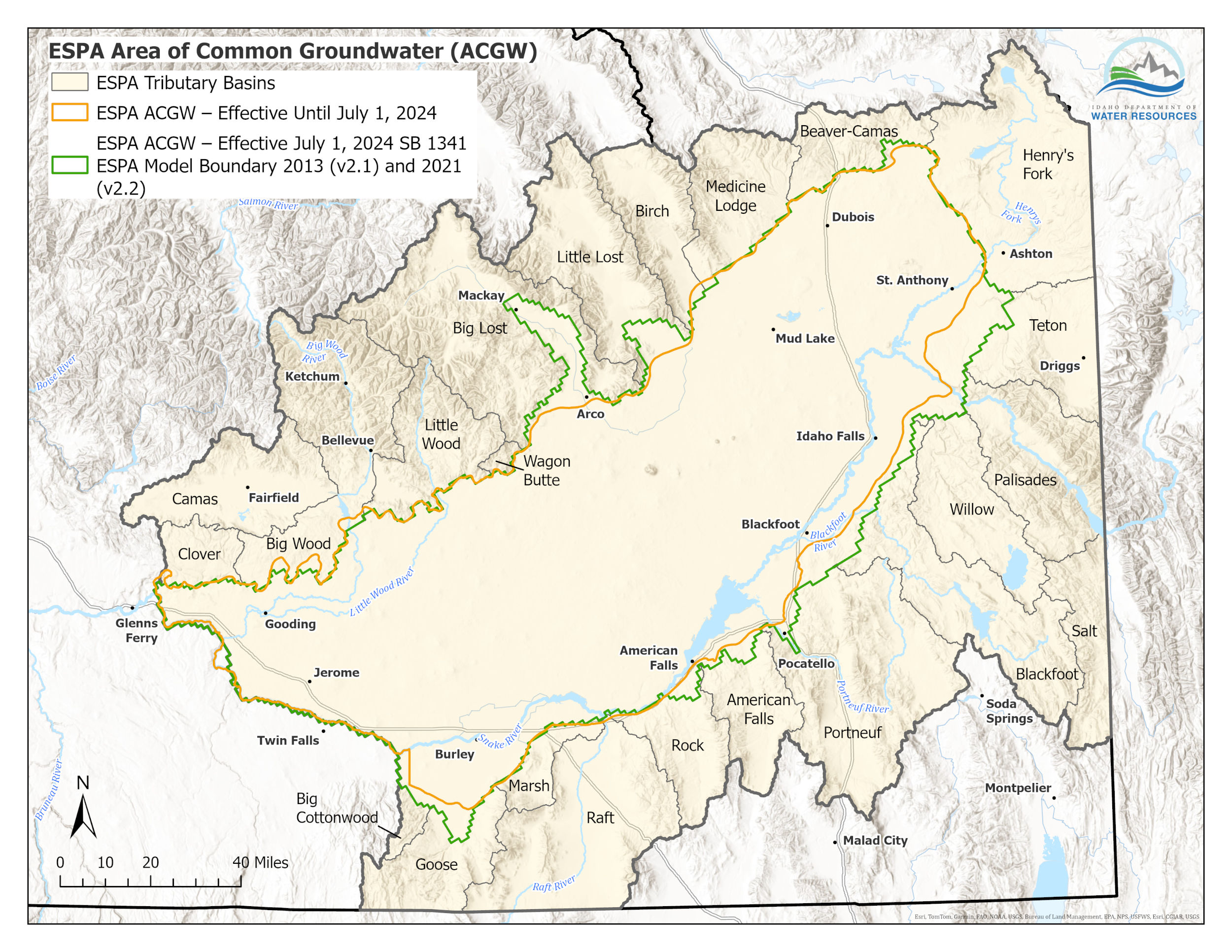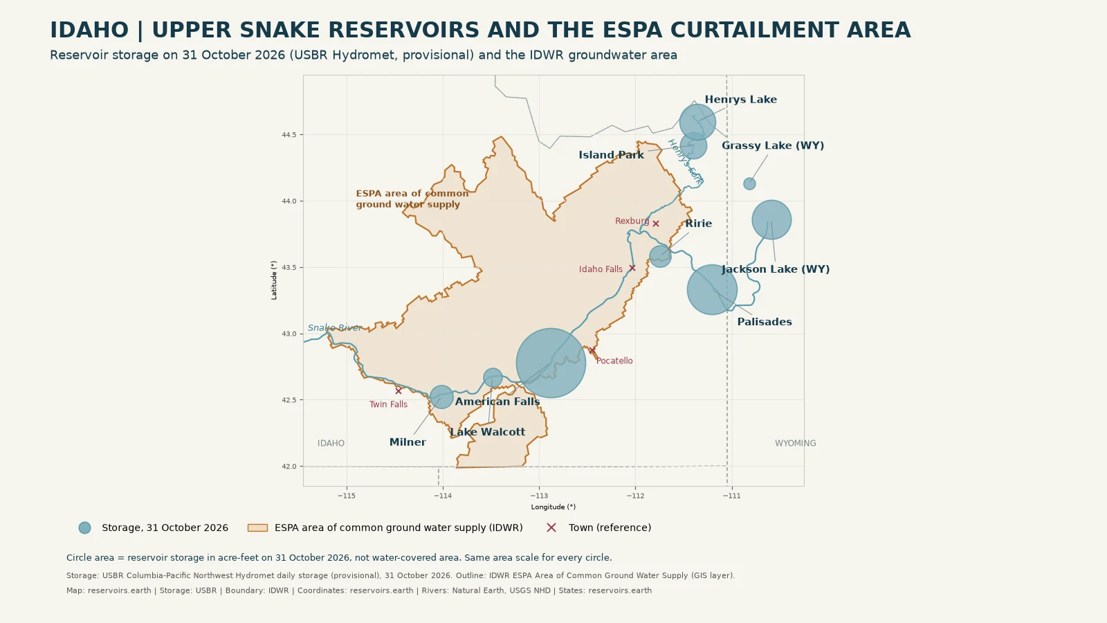
On 14 May 2026 the Idaho Department of Water Resources (IDWR) ordered holders of groundwater rights junior to 11 October 1900 in the Eastern Snake Plain Aquifer to stop pumping unless they were covered by an approved mitigation plan. On 21 July the Director kept that order in force and predicted a 741,100 acre-foot in-season demand shortfall for the Surface Water Coalition. After the irrigation season, Water District 1 reported the Upper Snake reservoir system's physical carryover on 31 October 2026 at 614,815 acre-feet, the second lowest of the past 30 years.
Quick answer: Idaho's 2026 groundwater curtailment is set by a predicted shortfall for senior surface-water users, not by a reservoir level. The 14 May order, as amended, is still in force. The Upper Snake reservoirs ended the season low: American Falls Reservoir water level was 250,074 acre-feet on 31 October and 348,447 acre-feet on 12 November, the latest day published as of 13 November 2026. For every tracked reservoir in the state, see Idaho reservoir levels.
Data as of: USBR Hydromet daily storage through 12 November 2026 (provisional), IDWR orders as posted on 12 November 2026, Water District 1 report of 4 November 2026.
What Idaho's 2026 curtailment order says
The case is the Surface Water Coalition (SWC) Delivery Call, IDWR Docket No. CM-DC-2010-001. The Coalition is a group of canal companies and irrigation districts that divert from the Snake River.
- 16 April 2026. The Final Order Regarding April 2026 Forecast Supply (Methodology Steps 1–3) predicted an April in-season demand shortfall (IDS) of 181,600 acre-feet. Groundwater users with consumptive rights junior to 11 October 1900 in the ESPA area of common ground water supply (ACGWS) had until 1 May 2026 to show they could mitigate their share under an approved plan.
- 14 May 2026. The Final Order Curtailing Ground Water Rights Junior to October 11, 1900 took effect. Users "holding water rights bearing priority dates junior to October 11, 1900, within the ESPA ACGWS, and listed in Attachment A" were ordered to "curtail/refrain from diversion and use of ground water", unless IDWR notified them that the order had been modified or rescinded for their rights. Holders of highlighted rights in Attachment A had fifteen days to join a ground water district for mitigation.
- Who is covered. IDWR says the order applies to consumptive groundwater rights, "including but not limited to, agricultural, commercial, industrial, and municipal uses". It excludes de minimis domestic use within Idaho Code § 42-111 and de minimis stock watering within § 42-1401A(11).
- Mitigation exception. Users protected by the approved plans of SWID, the Coalition of Cities, the Water Mitigation Coalition, A&B and the Ground Water Districts "will not be subject to curtailment during the 2026 irrigation season" (14 May order, Conclusion of Law 3).
- 17 June 2026. The Order Amending Curtailment List to Include Unmitigated Ground Water Rights added rights that were not in Attachment A. IDWR's status update says it "added six ground water rights whose mitigation coverage expired in 2025".
- 21 July 2026. The Order Revising April 2026 Forecast Supply and Continuing May 14, 2026 Curtailment Order (Methodology Steps 5 & 6) states: "The Director predicts an in-season IDS of 741,100 acre-feet." The 14 May order, as modified on 17 June, "remains in full force and effect". The curtailment date stays at 11 October 1900, "the priority date equal to TFCC's Water Right No. 1-209, the most senior SWC natural flows water right predicted to be injured".
- 24 July 2026. The docket lists an Order Rescinding 2026 Curtailment of DOE Water Right No. 34-10901.
The July order also records that groundwater users added to the ESPA ACGWS in late 2025 and early 2026, in the Raft River basin and the rest of the Little Lost and Big Lost basins, are not subject to administration before 1 April 2027.
How many water rights the order covers
IDWR's status update of 29 September 2026 lists 930 groundwater rights subject to the 14 May order: 548 "curtailment unnecessary" (59%), 352 "curtailed by user" (38%), 30 "investigation ongoing" (3%) and 0 not yet initiated (0%). The percentages are printed by IDWR. Its examples of "curtailment unnecessary" include rights within the domestic exemption, rights in an approved mitigation plan, and points of diversion where no well was found.
When checked on 12 November 2026, the newest docket entry was a scheduling and hearing order dated 29 September 2026. No later order was posted.
What triggers curtailment: a predicted shortfall, not a reservoir percentage
IDWR applies a court-approved Methodology Order, currently the Sixth Final Order Regarding Methodology for Determining Material Injury to Reasonable In-season Demand and Reasonable Carryover of 19 July 2023. Each season the Director sets the Coalition's Reasonable In-Season Demand (RISD) against its Forecast Supply. The July order says the IDS "is calculated as the difference between RISD and the FS". Junior groundwater users must then mitigate their proportionate share of that shortfall or be curtailed.
No reservoir fill percentage triggers curtailment. Reservoir storage enters the calculation as one input to Forecast Supply, through storage allocations. It is not a threshold.
IDWR's breakdown of the 741,100 acre-feet
The 21 July order (Finding of Fact 27) predicts shortfalls for five Coalition members, in acre-feet: AFRD2 154,800; BID 47,000; Minidoka 64,400; NSCC 185,500; TFCC 289,400. A&B and Milner: 0. Total as printed: 741,100.
Using its ESPAM2.2 aquifer model, IDWR found that continued curtailment "would produce a volume of water of 78,500 AF in the near Blackfoot to Minidoka reach between July 1 and September 30", less than the predicted IDS. That is IDWR's model result, not a reservoirs.earth estimate.
How much water the Upper Snake reservoirs hold
The columns are the day the curtailment took effect, the day of the July order, the end-of-season carryover date and the latest day published as of 13 November 2026.
| Reservoir | 14 May 2026 | 21 Jul 2026 | 31 Oct 2026 | 12 Nov 2026 (latest as of 13 Nov) |
|---|---|---|---|---|
| American Falls | 1,099,563 | 399,631 | 250,074 | 348,447 |
| Palisades | 499,349 | 360,240 | 129,429 | 168,729 |
| Jackson Lake (Wyoming) | 798,776 | 559,310 | 79,578 | 83,917 |
| Island Park | 131,571 | 65,597 | 36,420 | 42,721 |
| Henrys Lake | 88,257 | 81,958 | 67,226 | 68,206 |
| Grassy Lake (Wyoming) | 14,676 | 8,237 | 7,110 | 7,213 |
| Ririe | 59,877 | 53,135 | 24,111 | 25,028 |
| Lake Walcott (Minidoka Dam) | 85,749 | 89,238 | 18,032 | 19,333 |
| Milner | 38,282 | 37,759 | 27,732 | 27,281 |
Each column is one daily row as USBR publishes it. Milner is published with decimals and is rounded here to the nearest acre-foot. When checked on 13 November 2026, the row for 13 November was blank. No value has been filled in for that day.
USBR's Upper Snake teacup defines the "Upper Snake River system" as Jackson Lake, Palisades, Grassy Lake, Island Park, Ririe, American Falls and Lake Walcott, with a total storage capacity of 4,045,695 acre-feet. Henrys Lake and Milner are listed as well because they have official Hydromet storage series.
From 31 October to 12 November, American Falls and Palisades rose on every daily row. Water District 1 reported on 4 November that reservoir releases "have been reduced to their winter minimums throughout the system".
Palisades reservoir level and the other teacups on 3 November
USBR's teacup diagram dated 3 November 2026, reproduced on page 2 of Water District 1's 4 November report, printed these percentages full: Jackson Lake 10%, Palisades 12%, American Falls 17%, Island Park 28%, Henrys Lake 75%, Grassy Lake 47%, Ririe 30% and Lake Walcott 20%. It gave no percentage for Milner. These figures apply to 3 November only. They are not the fill on any other day, and none is calculated here.
The 31 October carryover (Water District 1)
Water District 1's report of 4 November 2026 states: "Physical reservoir system carryover as of October 31 was 614,815 acre feet, approximately 539,000 acre feet less than 2025 and the second lowest carryover of the past 30 years."
That figure is Water District 1's own accounting. The report does not list which reservoirs it covers. It is not the sum of the table above, which shows Hydromet physical contents on a different basis, and the table should not be added up to check it.
The same report says precipitation since 1 October has been above median across the basin, but that most of it fell as rain or melted, "leaving snowpack accumulation near zero and below the median for this date".
Why American Falls' 1921 right matters for 2027
Storage rights on the Upper Snake fill in priority order. Water District 1's 4 November report puts the risk this way:
Historical years with comparable carryover indicate a meaningful risk that the American Falls 1921 water right may not completely fill in 2027. If that occurs, junior reservoir water rights, including Island Park 1935, Palisades 1939, and Ririe 1969, would receive no new storage accrual.
This is Water District 1's statement of risk, not a forecast by reservoirs.earth. Next year's supply depends on the 2027 snowpack and runoff, which are not known yet.
Map: the Upper Snake reservoirs and the ESPA curtailment area
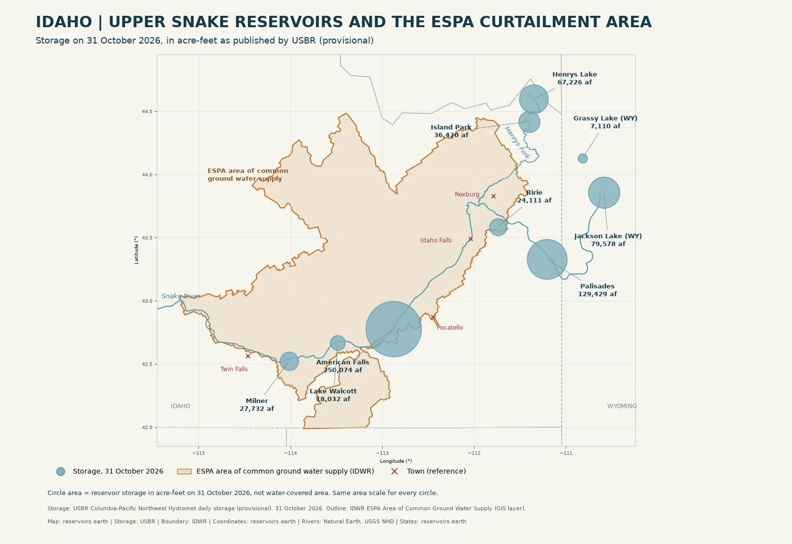
Original data visualisation. Circle area represents storage in acre-feet from USBR Hydromet (provisional) on 31 October 2026. The shaded outline is the ESPA area of common ground water supply from IDWR's published GIS layer, simplified for display. It includes areas IDWR added in late 2025 and early 2026 that are not administered before 1 April 2027. The circles do not show reservoir footprints. For the official boundary, see IDWR's ESPA ACGWS map (Map: Idaho Department of Water Resources), which IDWR says reflects the boundary that "went into effect on July 1, 2024" under Senate Bill 1341.