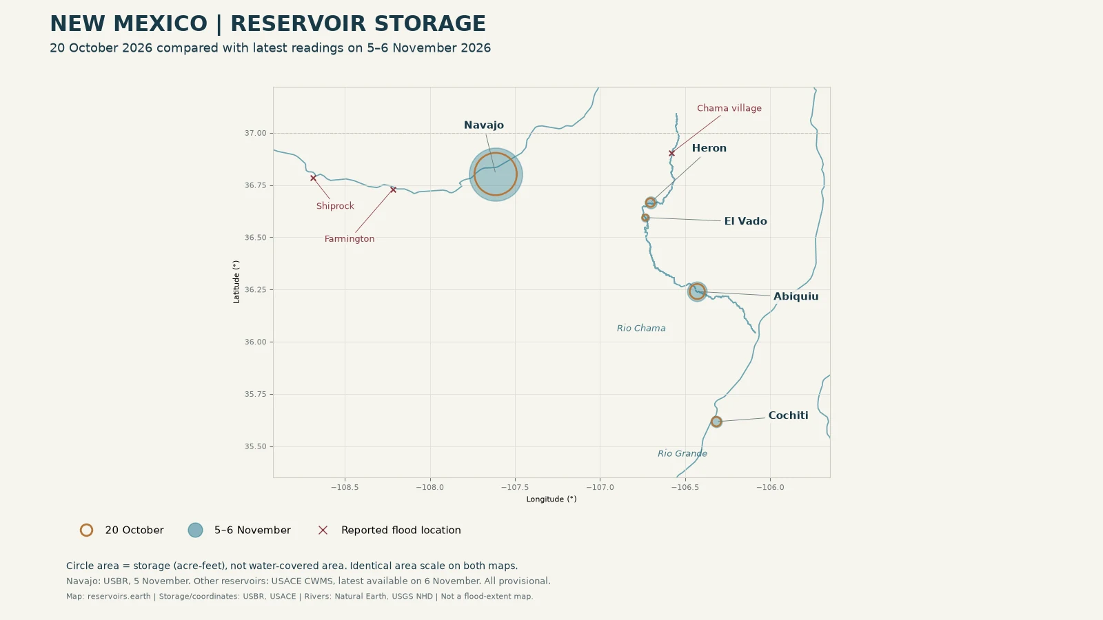
Navajo Reservoir held 880,063 acre-feet on 20 October 2026 and 1,388,941 acre-feet on 5 November 2026, according to the US Bureau of Reclamation (USBR). At Abiquiu, the US Army Corps of Engineers (USACE) recorded 112,306 acre-feet in its latest reading for 20 October and 188,673 acre-feet in its latest available reading on 6 November. Caballo, downstream of Elephant Butte, was comparatively little changed: 25,397 and 25,951 acre-feet in the USACE record for those comparison dates. All these observations are provisional.
What this comparison measures
This is a comparison of stored water, not a calculation of how much rain became reservoir inflow. Storage also reflects releases, operating decisions and other components of the water balance. It cannot establish that all the increase came from a particular storm, or that a reservoir prevented a particular flood downstream.
For Navajo, we use Reclamation's published 40-day series. For the other reservoirs, we select the final available 15-minute observation for 20 October in the USACE CWMS record, and the latest available observation on 6 November retrieved for this article. The latter is a partial-day reading, not a closing daily total. The baseline uses the agency record's UTC calendar day; the 6 November retrieval was capped at 09:00 Europe/Madrid. Values are presented to the nearest acre-foot, with no conversion to other units, no calculated percentage full and no calculated-change column.
Key takeaways
- Navajo, Abiquiu, Heron and Elephant Butte held more water in their latest official observations than in the 20 October baseline. The tables retain each agency's dates rather than presenting a synchronised statewide total.
- Caballo showed little change beside the larger movement at upstream Elephant Butte. These storage observations alone do not identify the operating reason.
- Conchas, Santa Rosa, Sumner and Brantley rose over the same period. We found no official source attributing their increases to the same northern New Mexico storm system.
- These are provisional storage records, not flood maps, safety assessments or forecasts.
Two periods of high water in northern New Mexico
The earlier pulse is visible in Reclamation's Navajo inflow series around 22–23 October. Its computed inflow was 2,163 cubic feet per second on 21 October and 44,238 cubic feet per second on 23 October (USBR, Navajo 40-day series, checked 6 November 2026). These readings indicate timing at Navajo; they are not an NWS event definition. The governor's office separately dates the beginning of the northern flooding to 22 October in its 29 October release.
Source New Mexico's report of 2 November describes further weekend rainfall and evacuation orders near the San Juan, La Plata, Animas and Chama rivers. It reports mandatory evacuation of the village of Chama on Sunday 1 November. The reporting supplies event context, not the reservoir measurements below.
The latest NWS statement retrieved on 6 November cancels the San Juan River at Shiprock warning at 06:48 Europe/Madrid on 5 November. It reports an observed stage of 13.2 feet at 06:00 Europe/Madrid on 5 November, below the stated bankfull stage of 13.5 feet (NWS Albuquerque, Shiprock flood statement). It should not be described as an active warning today. This article does not reproduce the statement's forecast.
In its 29 October release, the governor's office says the state committed $42.75 million to flood recovery. The same release puts the state's cumulative commitment at nearly $55 million over the preceding month, a figure that includes separate flooding on 30 September. It is not a single award for the two northern flood pulses. Funding is separate from the storage comparison.
Before and after: reservoir storage on the map
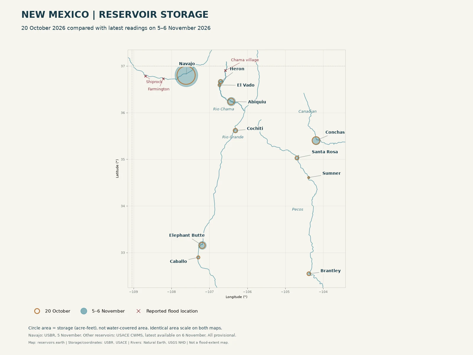
Original data visualisation, not shoreline photography. Circle area represents official storage in acre-feet on 20 October versus the latest selected reading on 6 November (Navajo: USBR, 5 November). All observations are provisional. Rivers are geographic reference lines; crosses mark places described in flood reporting, not a mapped flood boundary. No reservoir footprint or inundated area is inferred from the circles.
San Juan and the Chama headwaters
Storage below is in acre-feet. The 20 October baseline is dated in the agency's record. The November column gives the latest available observation selected for this article, not a forecast or full-day total.
| Reservoir |
River / system |
20 October 2026 |
Latest reading |
Reading date |
Agency |
| Navajo |
San Juan |
880,063 |
1,388,941 |
5 November 2026 |
USBR, 40-day series |
| Heron |
Willow Creek / Rio Chama |
36,967 |
70,529 |
6 November 2026 |
USACE CWMS |
| El Vado |
Rio Chama |
17,763 |
31,936 |
6 November 2026 |
USACE CWMS |
| Abiquiu |
Rio Chama |
112,306 |
188,673 |
6 November 2026 |
USACE CWMS |
Reclamation publishes elevation as 6,021.54 feet on 20 October and 6,067.35 feet on 5 November (USBR, 40-day series).
The USACE Navajo location page, checked 6 November, separately reports 1,388,942 acre-feet, elevation 6,067.35 feet, at 08:00 Europe/Madrid on 6 November. Its Conservation Storage Utilized is 70%, Flood Storage Utilized 0%, and Total Storage Utilized 66%. These are that agency's labelled measures, not a percentage full calculated here. The USBR and USACE observations are reported separately, without averaging them or treating different timestamps as identical.
At Abiquiu, the USACE page gives storage of 188,673 acre-feet and elevation 6,220.93 feet at 08:30 Europe/Madrid on 6 November. Its Conservation Storage Utilized is 100%, Flood Storage Utilized 0%, and Total Storage Utilized 11%. Those categories should not be interchanged. They do not mean that every part of Abiquiu's total storage space is occupied.
| Reservoir |
Conservation Storage Utilized |
Flood Storage Utilized |
Total Storage Utilized |
Agency / date |
| Navajo |
70% |
0% |
66% |
USACE location page, 6 November 2026 |
| Abiquiu |
100% |
0% |
11% |
USACE location page, 6 November 2026 |
| Other nine reservoirs in this comparison |
Not stated |
Not stated |
Not stated |
Not supplied by the CWMS storage series used here |
Rio Grande: Cochiti, Elephant Butte and Caballo
| Reservoir |
River |
20 October 2026 (acre-feet) |
Latest reading (acre-feet) |
Reading date |
Agency |
| Cochiti |
Rio Grande |
42,663 |
63,145 |
6 November 2026 |
USACE CWMS |
| Elephant Butte |
Rio Grande |
97,234 |
166,860 |
6 November 2026 |
USACE CWMS |
| Caballo |
Rio Grande |
25,397 |
25,951 |
6 November 2026 |
USACE CWMS |
Elephant Butte's recorded storage rose over the comparison period, while downstream Caballo remained close to its baseline. That contrast describes the observations, not a reconstruction of releases or the path of an individual parcel of floodwater. The Compact's legal accounting is a separate question, covered in the Rio Grande Compact and Elephant Butte storage rule.
Pecos and Canadian: increases over the same period
| Reservoir |
River / basin |
20 October 2026 (acre-feet) |
Latest reading (acre-feet) |
Reading date |
Agency |
| Conchas |
Canadian |
155,302 |
180,922 |
6 November 2026 |
USACE CWMS |
| Santa Rosa |
Pecos |
34,626 |
48,928 |
6 November 2026 |
USACE CWMS |
| Sumner |
Pecos |
8,503 |
15,181 |
6 November 2026 |
USACE CWMS |
| Brantley |
Pecos |
36,957 |
43,994 |
6 November 2026 |
USACE CWMS |
These reservoirs rose over the same period. The comparison does not establish that their storage increases resulted from the same storm system as the flooding on the San Juan or Chama. No such official attribution was found.
Sources and methodology
Sources checked on 6 November 2026, Europe/Madrid:
- USBR Navajo 40-day series: official provisional storage, elevation and computed inflow, retaining the dates Reclamation publishes. Latest storage available was dated 5 November.
- USACE location pages for Navajo and Abiquiu: separately dated observations and the agency's own storage-utilised percentages.
- USACE CWMS Data API: office SPA; instantaneous 15-minute storage series named
<reservoir>.Stor.Inst.15Minutes.0.DCP-rev. Reservoir identifiers are Abiquiu, Heron, El Vado, Cochiti, E Butte, Caballo, Conchas, Santa Rosa, Sumner and Brantley. The baseline is the final available sample for 20 October in the UTC record; the comparison uses the latest available sample on 6 November up to the retrieval cutoff. These selections are not agency-published daily averages or daily closing totals.
- Latest 6 November observation times in Europe/Madrid: Abiquiu, Cochiti and Santa Rosa 08:30; Sumner 08:45; Heron, El Vado, Elephant Butte, Caballo, Conchas and Brantley 09:00.
- NWS Albuquerque Shiprock statement: latest retrieved statement, a cancellation. This URL is mutable and can be replaced by subsequent notices.
- Source New Mexico, 2 November: evacuations and event chronology only. No news damage estimate is used as an independently verified statistic here.
- Governor's office, 29 October: dates and funding context, with the separate September event explicitly distinguished.
USBR and USACE observations are provisional and subject to review and revision. We round storage observations to the nearest acre-foot; we do not calculate fill percentages, differences for a change column, projected dates or distance to a spillway. Storage changes are not equivalent to storm inflow volume, flood damage avoided, entitlement or available allocation. The maps do not depict flood extent or current shoreline. This is general information, not legal, engineering or emergency advice. Follow current local authority and NWS instructions for safety decisions.
Map coordinates: USACE CWMS location API coordinates independently rechecked for ten reservoirs on 6 November; Navajo dam confirmed from the USBR project page at 36.802369, -107.612972. Geographic river reference data: Natural Earth and USGS NHD. These are not current river-stage maps.
Cite this page: reservoirs.earth, "New Mexico's October–November 2026 Floods: How Much Water Reached the State's Reservoirs", data as of 6 November 2026, https://reservoirs.earth/the-reservoir/new-mexico-floods-reservoir-storage-october-november-2026.
Related: New Mexico reservoir levels, July 2026 · New Mexico state data · Navajo Reservoir · Abiquiu Reservoir · Elephant Butte