
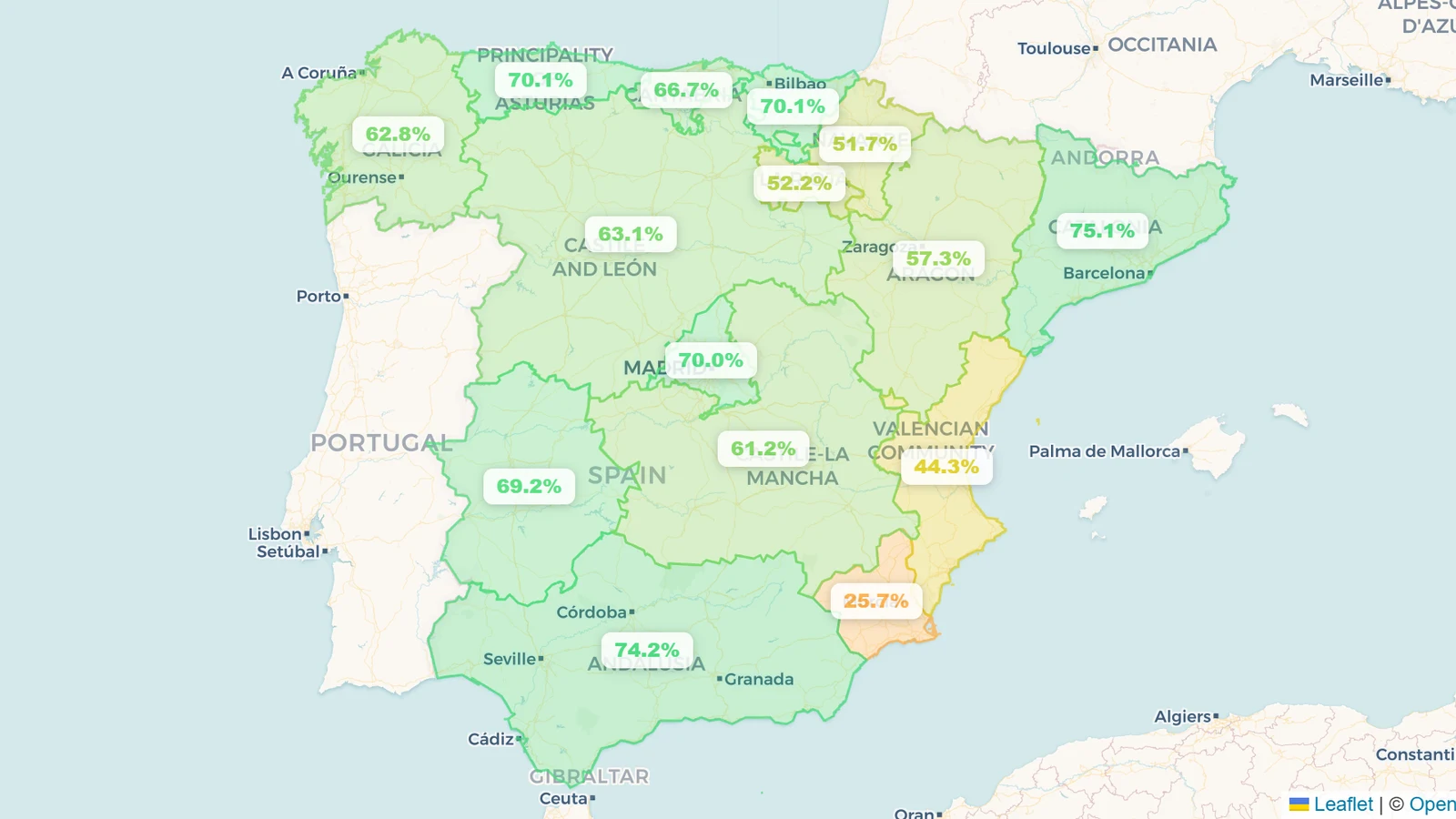
Spain's reservoirs were 66.2% full on 18 August 2026 — about 37.1 of 56.5 km³ across the 401 dams in the MITECO bulletin, some 13 points above the ~53% August normal we compute from the same series. Eight days earlier, the Puertos del Estado buoy at Sa Dragonera, off Mallorca, had logged 33.02 °C at the surface, 1.15 °C above the 31.87 °C recorded at the same station on 12 August 2024. That 2024 reading was the previous high for the Spanish outer-buoy network. It was also the sea-temperature backdrop to Storm Boris in September and the Valencia DANA on 29 October, events in which a very warm Mediterranean supplied most of the moisture. Live figures are on the Spain page.
Key takeaways
- Spain is 66.2% full (18 August 2026) — 37.1 km³ of a 56.5 km³ capacity, about 13 points above a ~53% August normal and about 4 points above the same mid-August week in 2025 (62%). The Spain page carries the live map.
- The Balearic Sea has broken the 2024 record by more than a degree. Sa Dragonera hit 33.02 °C on 5 August 2026, against 31.87 °C on 12 August 2024. SOCIB puts the regional ten-day average at 29.5 °C, 3.7 °C above the 1982–2015 baseline, with a satellite peak of 29.7 °C on 15 August.
- A hotter sea holds more fuel for extreme rain, it does not schedule the storm. In 2024 the Mediterranean supplied about 78% of the moisture for the Valencia DANA, and model experiments found rainfall that day would have been up to 40% lower without the observed sea-surface temperature anomalies. This year's starting temperature is higher. A DANA still has to form.
- The reservoirs that would receive that rain are not where they were in 2024. On 29 October 2024 the internal basins of Catalonia sat at 28% and the Segura at 15%. By 31 December the Júcar had climbed from 40% to 50%; Spain as a whole had barely moved, from 50% to 52%. Today those same systems are at 80% and 54%. The Júcar is 56.4%.
- Room to take water and risk of too much water now sit in different basins. Tous on the Júcar is 24% full. Sau, which supplies Barcelona, is 79%. A wet autumn would refill the southeast. It would test flood operations in Catalonia.
What the buoys recorded
The figure that moved on 5 August came from a single sensor. The Sa Dragonera buoy, run by Puertos del Estado and flagged that afternoon by the meteorologist Duncan Wingen, climbed from 29.94 °C at 09:00 to 33.02 °C around 16:00, a reading AEMET's Balearic delegation then confirmed. The previous maximum at that station — and the highest in the Spanish outer-buoy network — was 31.87 °C on 12 August 2024. The new mark is 1.15 °C above it. It is a point measurement, not a beach-by-beach average, and it does not mean every cove in Mallorca reached 33 °C.
The rest of the network was not far behind. The Maó buoy logged 32.3 °C on 8 August. Palma Bay hit 31 °C the same day. The Pollença tide gauge reached 32.1 °C on 11 August. SOCIB's Mélanie Juza, speaking to EFE in mid-August, called the basin state "unprecedented in August in the Balearic Sea": a 29.5 °C regional average over ten days, 3.7 °C above the 1982–2015 normal, and a satellite record of 29.7 °C on 15 August, against a previous first-half-of-August high of 29.2 °C. The western Mediterranean as a whole is running more than 3 °C above that same baseline.
None of this is a one-day spike. SOCIB detected a marine heatwave in the Balearics as early as May, then a second, long event from mid-June that was still in place in the third week of August. That is the same seasonal window that, in 2024, ran from a record-warm sea in August into the autumn storms.
Why a degree and a bit more sea heat matters for rain
Warm water evaporates more readily. The atmosphere above it can also hold more vapour: the Clausius–Clapeyron relation is about 7% more moisture per 1 °C. A marine heatwave does not, on its own, produce a flood. It loads the lowest layer of the atmosphere so that when a cut-off low — a DANA, in the Spanish usage — or a slow-moving cyclone sets up over the basin, the air that feeds it is wetter.
That is what 2024 demonstrated, twice.
Storm Boris, in the second week of September 2024, formed over western Europe, moved toward the Mediterranean, and then dumped extreme rain on Germany, Poland, Austria, Hungary, Czechia, Slovakia, Romania and Italy. Copernicus was direct about the mechanism: above-average air temperatures and sea-surface temperatures in the Mediterranean and the Black Sea "favoured the evaporation of large amounts of moisture into the atmosphere, which was subsequently transported into central Europe."
The Valencia DANA of 29 October 2024 was closer to home. A quasi-stationary cut-off low parked between Spain and Morocco and drove easterly flow onto the Valencian coast. Turís recorded 771.8 mm in 24 hours, the second-highest daily total in the Spanish record. At least 232 people died. A moisture-tracking study in Atmospheric and Oceanic Science Letters found the Mediterranean supplied 78.1% of the water that fell. A follow-up modelling paper in Weather and Climate Extremes went further: with the observed Mediterranean and North Atlantic sea-surface temperature anomalies removed, rainfall totals that day would have been up to 40% lower.
So the 2024 sea-temperature record was not a curiosity sitting next to the floods. It was part of the fuel. This August the same buoy is 1.15 °C hotter than that record, and the Balearic basin as a whole is several degrees above its own climatology. If a similar synoptic setup appears this autumn, there is more moisture available to it. That is a physical statement, not a forecast that 2026 will out-rain 2024. The storm still has to form, stall in the right place, and hit the right terrain.
What the reservoirs looked like then, and what they look like now
The other half of the 2024 story is how empty the Mediterranean catchments were when the rain arrived, and how little of that rain the national store actually kept. Our MITECO series, the same one on the Spain page, puts national storage at 52.3% on 18 August 2024 and 50.0% on 29 October, the day of the DANA. By 31 December 2024 Spain was still only 51.7%. The flood was real. The refill, at country scale, was not.
The basins under the storm did move. The Júcar, which includes the reservoirs above Valencia, went from 40.3% on DANA day to 49.8% by year-end, and most of that jump had already landed by 5 November (47.6%). The Segura rose from 14.7% to 21.3%. Catalonia's internal basins, still in drought recovery and mostly north of the storm, went from 28.4% to 33.4%. Two years on, the starting point is different.
| Basin | 18 Aug 2024 | 29 Oct 2024 (DANA) | 31 Dec 2024 | 18 Aug 2026 | August normal |
|---|---|---|---|---|---|
| Spain (national) | 52.3% | 50.0% | 51.7% | 66.2% | ~53% |
| Júcar | 43.9% | 40.3% | 49.8% | 56.4% | ~36% |
| Segura | 18.3% | 14.7% | 21.3% | 54.0% | ~27% |
| Cataluña (internal) | 32.3% | 28.4% | 33.4% | 79.9% | ~60% |
| Cuenca Mediterránea Andaluza | 26.0% | 21.6% | 29.2% | 68.9% | ~49% |
A basin average still hides where the water actually went. Forata, on the Magro in the province of Valencia, jumped from 13.5% on 29 October to 73% by mid-December. Tous, the flood-control dam on the lower Júcar, roughly doubled, from 16% to 32.5%. Sau, which sits outside the DANA footprint, kept falling.
| Reservoir | 29 Oct 2024 | 31 Dec 2024 | 18 Aug 2026 |
|---|---|---|---|
| Forata (Júcar / Magro) | 13.5% | 73.0% | 48.6% |
| Tous (lower Júcar) | 15.8% | 32.5% | 23.7% |
| Contreras (Júcar) | 45.4% | 58.2% | 71.7% |
| Cenajo (Segura) | 10.8% | 19.9% | 63.6% |
| Sau (Catalonia) | 21.8% | 16.4% | 78.8% |
The August normals are capacity-weighted averages of each reservoir's own August climatology in our history files, not a ten-year MITECO published mean. They exist so a 56% Júcar in August can be read as high for the season, which it is. The December 2024 column is the closest bulletin to year-end after the DANA (reading of 31 December).
Nationally, 66.2% in mid-August is a comfortable summer figure. It is also a drawdown from 77% on 6 July: Spanish reservoirs are doing what they always do in summer, releasing for irrigation and hydropower. The surplus to the seasonal norm has held. Live numbers, and the map of that surplus, are on the Spain page. Spain's data openness is scored in the Reservoir Transparency Index.
The Mediterranean basins, one by one
The Júcar is the basin the 2024 DANA actually hit. It holds 1,605 hm³ of a 2,846 hm³ capacity, 56.4% full as of 18 August 2026, against a ~36% August normal and 40% on the day of the flood. Headwaters storage is healthy: Alarcón is 73.8% (825 of 1,118 hm³) and Contreras 71.7%. Closer to the coast the picture thins. Tous, the large flood-control dam on the lower Júcar, is 23.7% — 90 hm³ in a 379 hm³ bowl, which is a lot of empty volume if a cut-off low stalls over Valencia again. Forata, on the Magro, sits at 48.6%. Bellús is 23.2%. The Valencian Community as a whole, mixing Júcar and Segura dams, is 44.3% (864 of 1,950 hm³). That is the lowest large autonomous community after Murcia. It still has room.
The Segura has had the sharpest two-year recovery of any Mediterranean system we track. It is 54.0% full (616 of 1,140 hm³) against 15% on 29 October 2024 and a ~27% August normal. Cenajo, the basin's largest dam, is 63.6%. Fuensanta is 75.7%. La Pedrera, which supplies Alicante, is 40.7%. The Region of Murcia itself remains the driest community in Spain at 25.7% (38 of 148 hm³), with Valdeinfierno and Alfonso XIII empty. Murcia's small local dams were not the 2024 flood story and they are not full now. The Segura's big upstream stores are.
Catalonia is the system that no longer needs the rain. The internal basins that supply Barcelona — under a drought emergency in early 2024, with the drowned village at Sau back above water — are 79.9% full (541 of 740 hm³). Sau is 78.8%. Susqueda is 82.4%. La Baells is 78.9%. Two years ago these same dams were in the low thirties. A repeat of an autumn DANA here is a spillway and downstream-flood problem, not a drought-relief one.
Andalusia's Mediterranean coast is full, with a dry eastern tail. The Cuenca Mediterránea Andaluza is 68.9% (809 of 1,174 hm³), against 22% on DANA day 2024. Guadalhorce-Guadalteba is 93.9% and La Viñuela 87.3%. Cuevas de Almanzora in Almería is the exception at 7.5%: the arid southeast still has a corner that would take whatever rain arrived.
MITECO's bulletin does not cover the Balearic or Canary Islands. The heat is being measured in the sea off Mallorca; the large surface reservoirs that would register an autumn flood sit on the peninsula. That is why this piece reads the Spanish confederations, not a Mallorcan dam.
Cyprus: the eastern Mediterranean still has space
The other Mediterranean country we track is in a different position. Cyprus was 40.2% full on 19 August 2026 — 120.5 of 300.1 hm³ across 21 dams, from the Water Development Department's own monitor. Kouris, the island's largest, is 39.6% (46 of 115 hm³), 25.7 points above the same date in 2025 and right on its August normal. Larnaca district is at 24.3%. Famagusta's Achna, often empty by design because it is fed by the Southern Conveyor rather than a river, is 1.4%.
Cyprus went into 2025 with a genuine storage crisis. It has not fully rebuilt. A wetter eastern-Mediterranean autumn would still be a refill here, not a flood-control test. The island's 39-year record is on the Cyprus page.
What the sea temperature does not decide
Three things this reading does not tell you.
A 33 °C buoy is not a rainfall forecast. The DANA of October 2024 required a cut-off low that stayed put for hours over the right stretch of coast. Most Augusts produce marine heat. Most Augusts do not produce a Turís. The extra moisture raises the ceiling on what a storm can drop if the setup returns. It does not book the setup.
Fuller reservoirs change the impact, not the physics. In 2024 the rain fell on catchments that had been in drought for two years. Soil took some of it; empty dams took some of it; the rest went down streets in Paiporta. In 2026 the Segura and the Júcar have more water already in store, which is a better irrigation starting point and a smaller sponge. Catalonia's internal basins, at 80%, have little sponge left at all.
Autumn, not August, is the season that counts. Spanish reservoirs refill on September-to-March rain. The 2024 floods arrived in September and late October, after the sea had already posted its record. The 2026 sea record is in the same slot on the calendar. The Spain page will show, week by week, whether that moisture stays in the sea or arrives as inflow.
For the July snapshot of the same Spanish system, see Spain reservoir levels, July 2026. For how Spain's water-data openness ranks, the Reservoir Transparency Index.